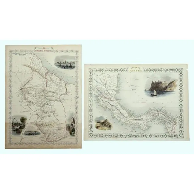
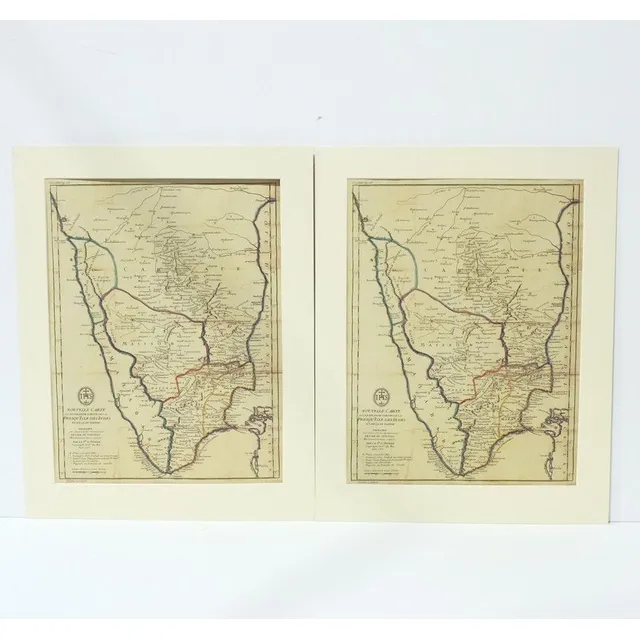
Tallis' 1851 Maps of Panama and British Guayana
Maps, Tallis, Panama & British Guayana. Isthmus of Panama with hand coloured delineation including Proposed canal; & British Guayana; both with coloured vignettes by John Rapkin, pub. By Tallis & Co. London, 1851. Hand coloured steel engraving, 37 x 27 cm…
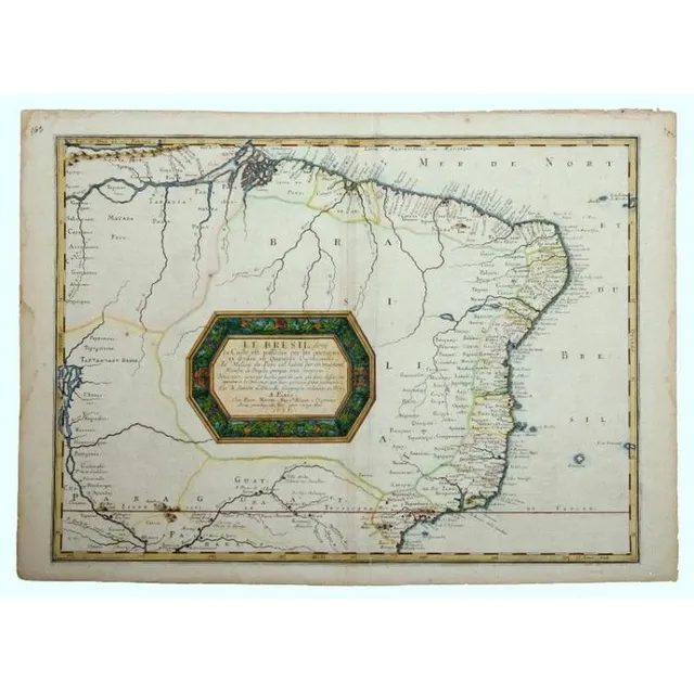
Brazil Map by Nicholas Sanson, 1656
Map, Sanson, Le Bresil, dont la Coste. Brasil from the Amazon to Rio de Janeiro by Nicholas Sanson, pub. Paris, 1656. Later colouring to cartouche. Hand coloured copper engraving, 40 x 55 cm
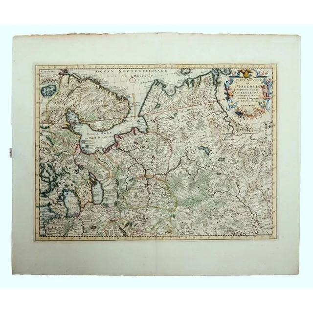
"Northern Russia Map, Ottens 1720"
Map, Ottens Carte Nouvelle Moscovie. Map of Northern Russia after cartographer de L'Isle, pub, by Reiner & Joshua Ottens, Amsterdam, 1720. Hand coloured copper engraving, 42 x 56 cm
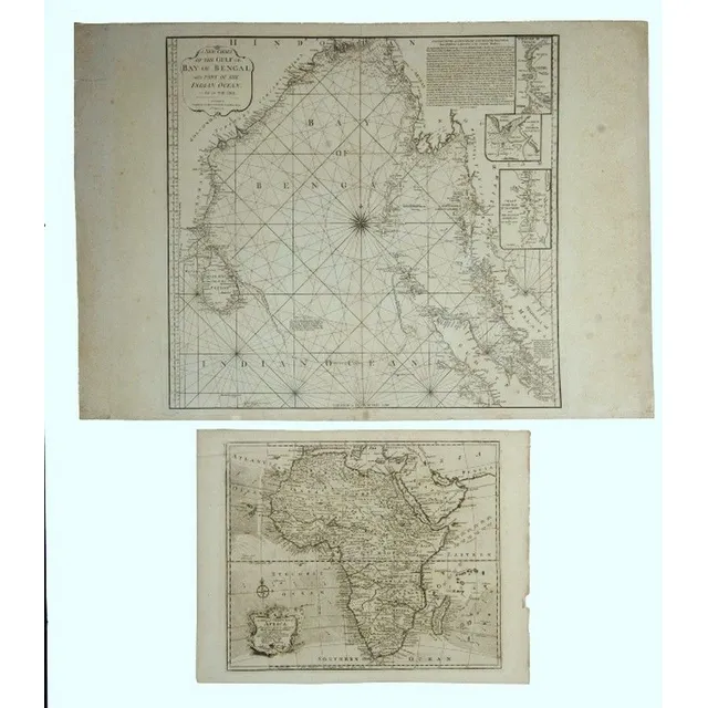
Africa & Bay of Bengal Maps
Maps 2, Africa & Bay of Bengal. A new & correct map of Africa, by Emanuel Bowen, pub. London 1744; & a new Chart of the Gulf or Bay of Bengal, by Laurie & Whittle, pub. London, 1797. Copper engraving, 38 x 46 cm & 62 x 66 cm
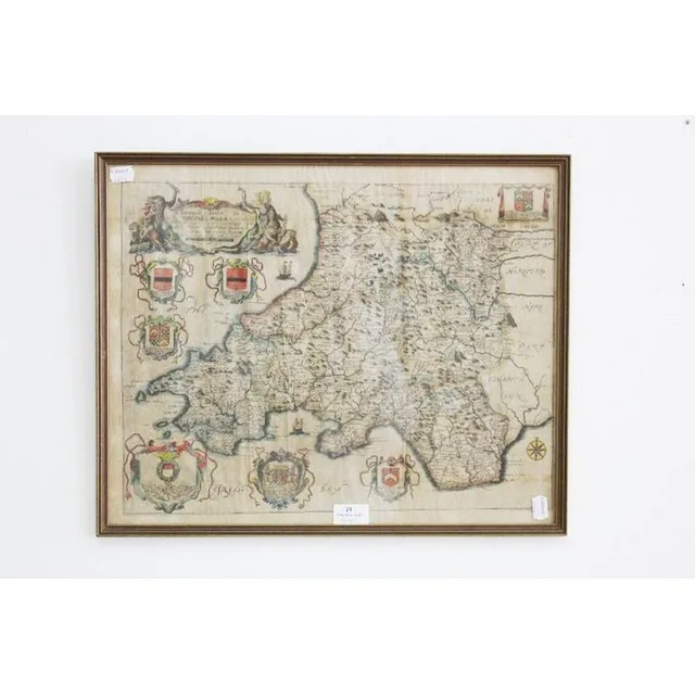
1690 Richard Brome Map of South Wales
Antique map dated 1690 by Richard Brome of south Wales, approx 38 cm x 47 cm
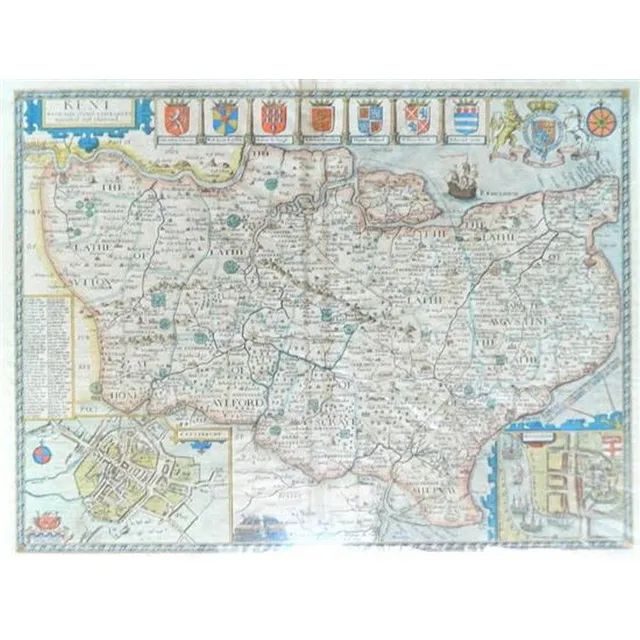
Kent with Cities and Earls by John Speede (1612-1616)
John Speede, (1552-1629) British, Kent with her Cities and Earles, as described and observed 1612-c.1616, Handcoloured engraving Published London, sold by G Humble in Popes head Alley, English text to the verso, 38.5 x 51.5 cm. Literature: John Speede was…
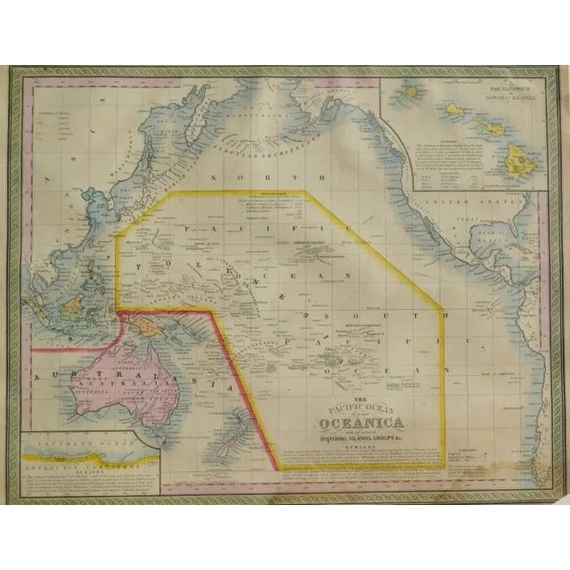
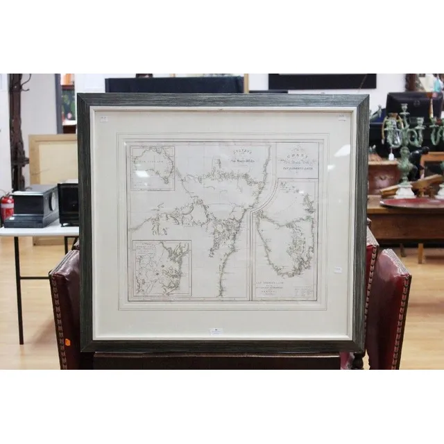
Antique Hand Coloured Maps of Pacific and Australia-Oceanica
Australian Interest: two framed hand coloured antique Maps i) the Pacific Ocean, including Oceanica Entered 1850 by Thomas Cowperthwait & Co, USA 32 x 40 cm (image) ii) Johnson's china, East Indies, Australia and Oceanica, circa - mid 19th century, by…
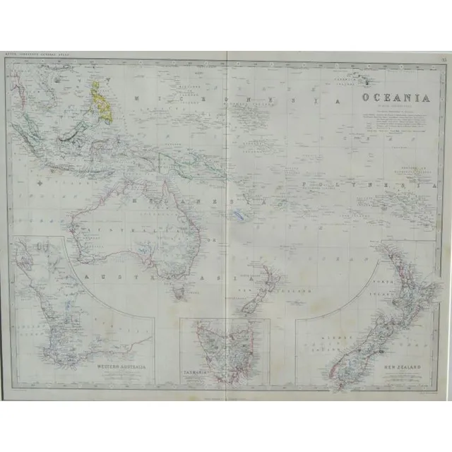
Antique Hand Coloured Maps of Oceania and New Zealand
Australian Interest: two framed hand coloured antique Maps i) Oceania Keith Johnston's General Atlas, London 44 x 57 cm ii) West-Australien & Neu Seeland (New Zealand ) c.1863, Stieler's hand-Atlas 33 x 40.5 cm
Rare Map of New South Wales and British Settlements
Rare Chart / Map of New South Wales (Van Diemen's Land) & Survey in the Interior of New South Wales, also showing the British Settlements at Port Jackson, J, Aspin, Hewitt Buckingham Place, approx 52 cm x 62 cm (Excellent condition, framed and glazed) See…
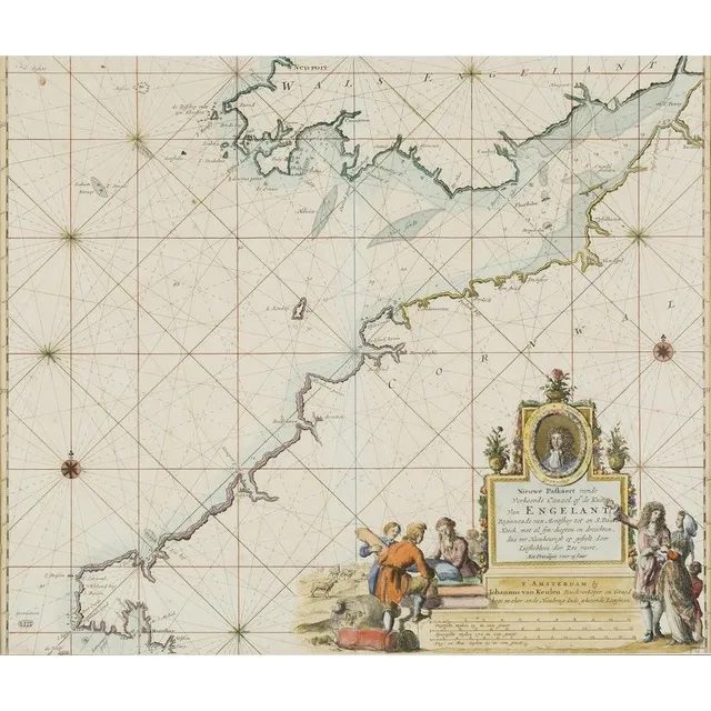
Hand-Coloured Map of England, 1681
Ionhannah Van Keulen, Engeland, hand coloured map, circa. 1681, 50 cm high, 55 cm wide

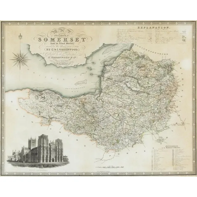
Somersetshire Map, 1787
L. Cary, Map of Somersetshire, hand coloured engraving, circa.1787, 39 cm high, 51 cm wide
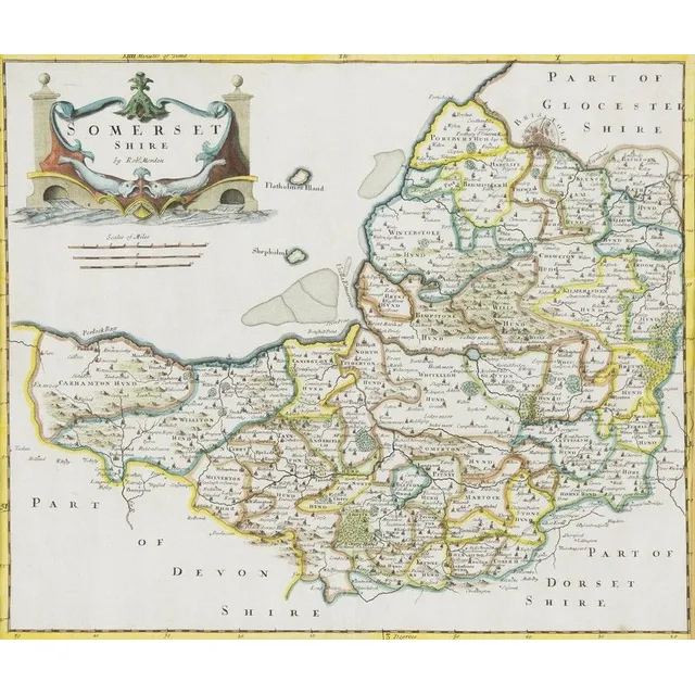
Hand-Coloured Map of Somersetshire (1695)
Robert Morden, Somersetshire, hand coloured map, circa. 1695, 35 cm high, 41 cm wide
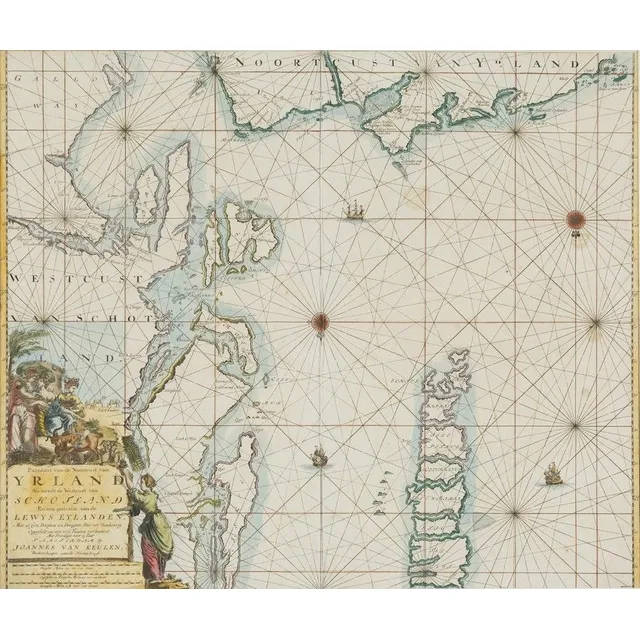
Hand-Coloured Map of Scotland and Ireland (1681)
Jjoannes Van Keulen, Yrland, Schotland, hand coloured map, circa. 1681, 50 cm high, 58 cm wide
Hand-Coloured Map of England by Saxton and Kip
Christoper Saxton, Hand coloured engraved map by William Kip, circa. 1575, 38 x 27.5 cm
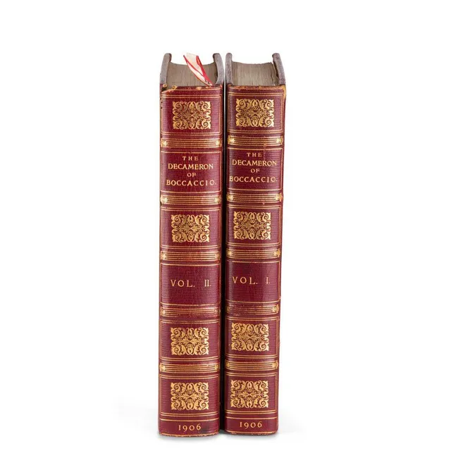
Boccaccio's Decameron with Cary Grant's Bookplate
Boccaccio (Giovanni): 'The Decameron', London 1906, 2 vols, illustrated by Louis Chalon, full morocco gilt, silk endpapers, with the bookplate of Cary Grant
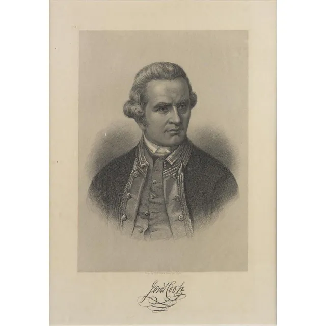
Captain Cook Chart and Portrait
Captain Cook: 'A New and Complete Chart of the World, Displaying the Tracks of Captn Cook, and other Modern Navigators' by Thomas Bowen [London, c1787], plus Portrait of Captain James Cook 'Engd. by H.B.Hall's Sons, New York' [c1880]. Both framed, various…
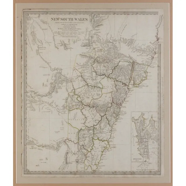
Antique NSW maps: Lizars & Society for Useful Knowledge
NSW Maps: 'Map of Part of New South Wales' by Lizars [Edinburgh, 1824], plus 'New South Wales, Compiled under the Superintendence of the Society for the Diffusion of Useful Knowledge' [London, 1833], both framed, various sizes.
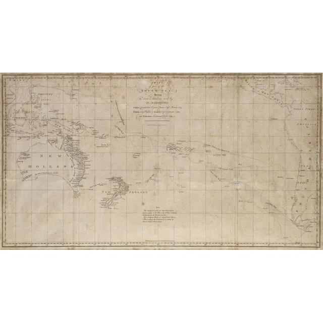
South Sea Discoveries Chart, 1765-1769
Chart of part of the South Sea shewing the tracts & discoveries made by His Majestys Ships Dolphin...& Tamer....1765, Dolphin...& Swallow...1767, and Endeavour, Lieutenant Cooke, 1769', engraved by W.Whitchurch [London, 1773], window mounted, framed &…
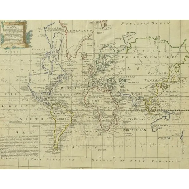
1744 Hand-Coloured World Map by Emanuel Bowen
After Emanuel Bowen: a New and Accurate Chart of the World, hand coloured framed map bearing date 1744 upper right 36 x 44 cm (image)
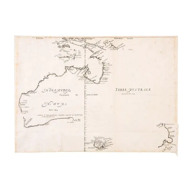
First Map of Australia, 1644
First Large-Scale Map of the Australian Continent 'Hollandia Nova detecta 1644, Terre Australe decouverte l'an 1644' by Melchisedech Thevenot [Paris, 1644]. The very rare first issue in its first state: with the latitudes incorrectly numbered, without the…
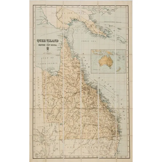
Queensland and British New Guinea 1897' large format map printed by the Surveyor General's Office, Brisbane, in 36 sections laid down on stiffened linen. Overall 103 x 69.5 cm.
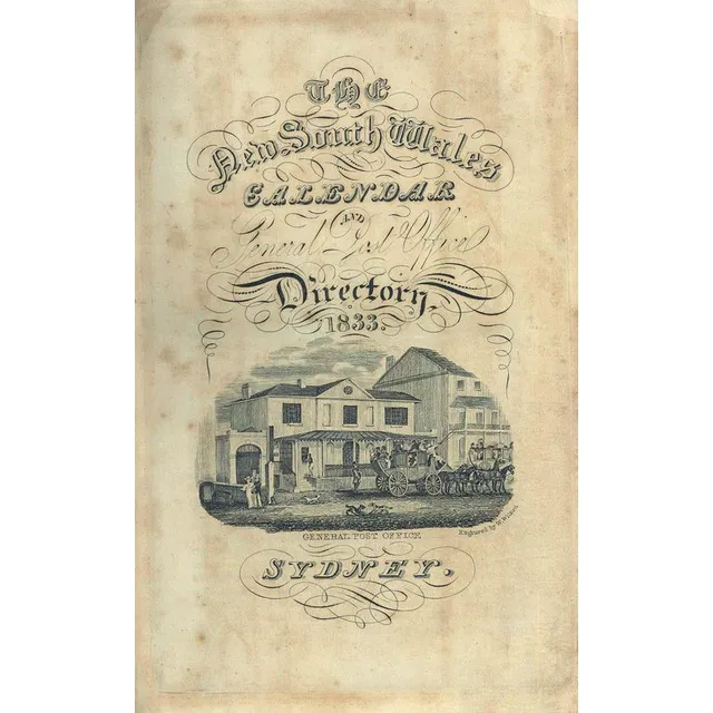
1833 NSW Calendar & Directory with Mitchell's Blue Mountains Pass
Stephens & Stokes: 'New South Wales Calendar and General Post Office Directory, 1833.' [Sydney: December, 1832.] with folding map, engraved title-page with view of the GPO, two folding tables, two folding plates (one hand-coloured), map of Mount Victoria,…
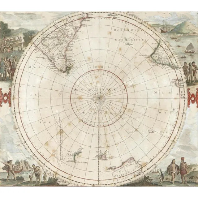
Antarctic Region Map with Tasman's Discoveries
De Wits edition of the Hemispherical map of the Antarctic Region by Hondius, 1680, originally published by Hondius, 'Polus Antarcticus' went through several changes. This edition shows Tasman's discoveries from his 1st voyage in Australia and New Zealand.…
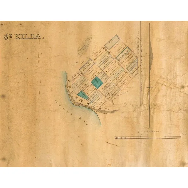
St Kilda, Victoria Map, 1840
A map of St Kilda, Victoria, c. 1840, lithograph with watercolour highlight on paper backed on linen, 30 x 36.5 cm
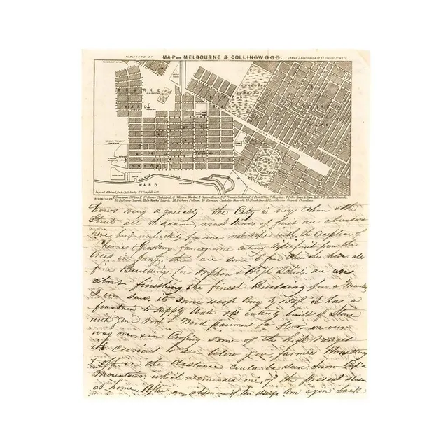
1854 Melbourne Map & Letter on Firearms Sales in Victoria
A lettersheet (folded to provide 4 sides) headed 'Map of Melbourne & Collingwood' with a detailed representation of the street grid, gardens and some significant buildings, with numbered references below the map. [Published by Blundell, engraved and…
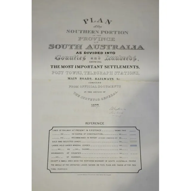
South Australia County and Hundred Atlas 1877
Goyder: Atlas of South Australia as Divided into Counties and Hundreds 1877
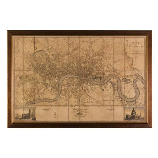
Greenwood's 1827 Map of London
A large map of London after the original by C & J Greenwood, 1827, 124 x 192 cm
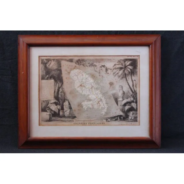
French Colonies Map, Martinique, 1856
Map mid 19th century, 'Colonies Francaise', 'Martinique Amerique ' by Victor Levasseur, c.1856, handcoloured etching, framed, 30 cm x 42 cm
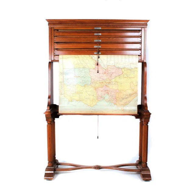
Vintage Australian Map Stand
Map stand, early 20th century classic style yellow oak (maple?), stand containing five state maps on Rollers showing pastoral Stations of Australia etc, by H E C Robinson Ltd George Street Sydney
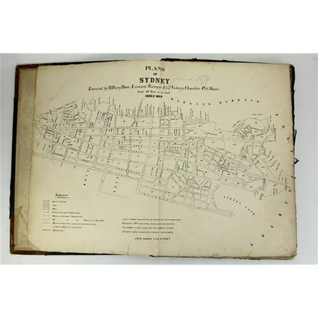
Sydney Plans 1880: Detailed Hand-Coloured Lithographs
John Sands 'Plans of Sydney By Executed H. Percy Dove' Licenced Surveyor 1 & 2 Vickerys Chambers Pitt Street. Scale 40 feet to an inch. Totaling ninety-six hand coloured lithographed pages on inner Sydney circa 1880. the first, unnumbered, map on the…
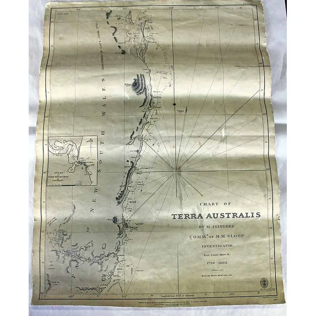
Flinders' Chart of Terra Australis (1799-1802)
A Cahrt of Terra Australis, 'By M. Flinders, Comm'r. Of H.M. Sloop Investigator. 1799-1802''. Paper on canvas. Engraved by J. & C. Walker, circa 1858. 64.5 x 47.6 cm
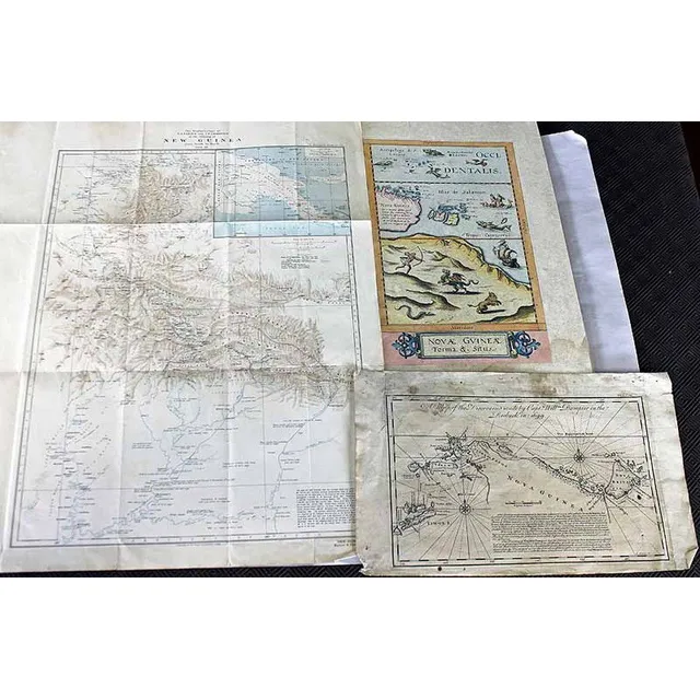
Dampier's Discoveries and New Guinea Explorer's Maps
A map of the Discoveries made by Captain William Dampier, circa 1744. Together with two Explorer's maps of New Guinea
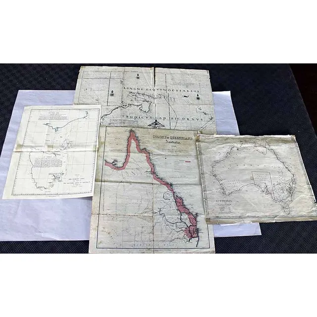
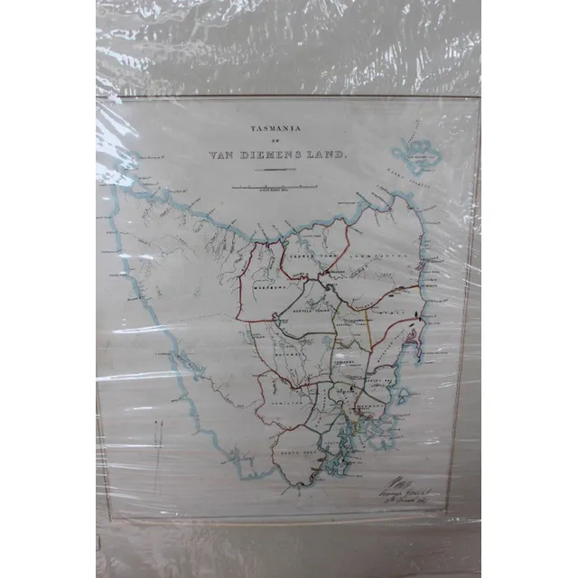
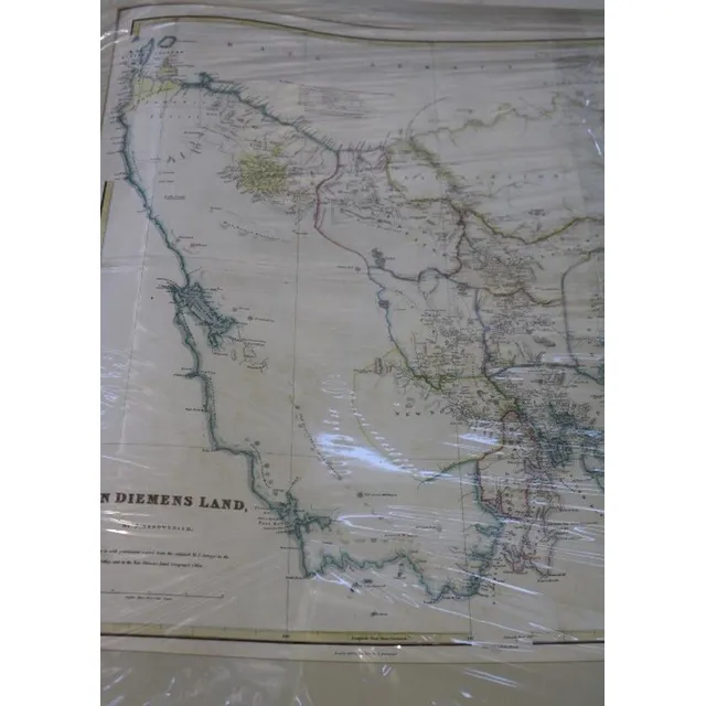
Colonial Maps of Australia and Van Dieman's Land
Four Colonial maps, including 'Colony of Queensland Australia' and 'Chart of van Dieman's Land'
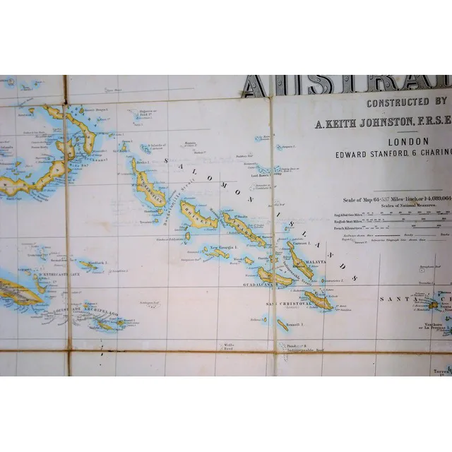
Bishop Patteson's Rare Map of Australasia, 1859
Bishop John Coleridge Patteson's personal copy of the rare 'Stanford's map of Australasia, London: Edward Stanford, 1859. First edition. Steel engraved map with hand colouring, total 155 cm x 174 cm, dissected into 48 sections, laid onto linen edged with…
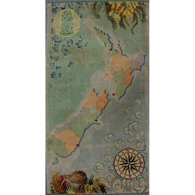
Vintage Feltex NZ Map Rug with Hei Tiki & Compass
A vintage Feltex New Zealand map rug, machine woven in colours, hei tiki in rondel top left corner, a compass bottom right. 128.5 cm x 68 cm
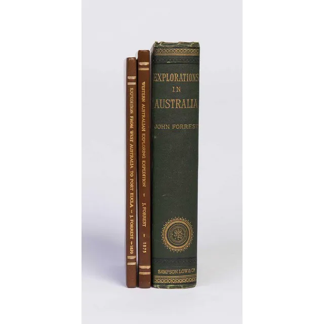
Australian Exploration Journals with Maps and Plates
Forrest, John. Explorations in Australia. 1. Explorations in search of Dr. Leichhardt and party. 2. From Perth to Adelaide, around the Great Australian Bight. III. From Champion Bay, across the desert to the Telegraph at Adelaide. London, 1875. Octavo,…
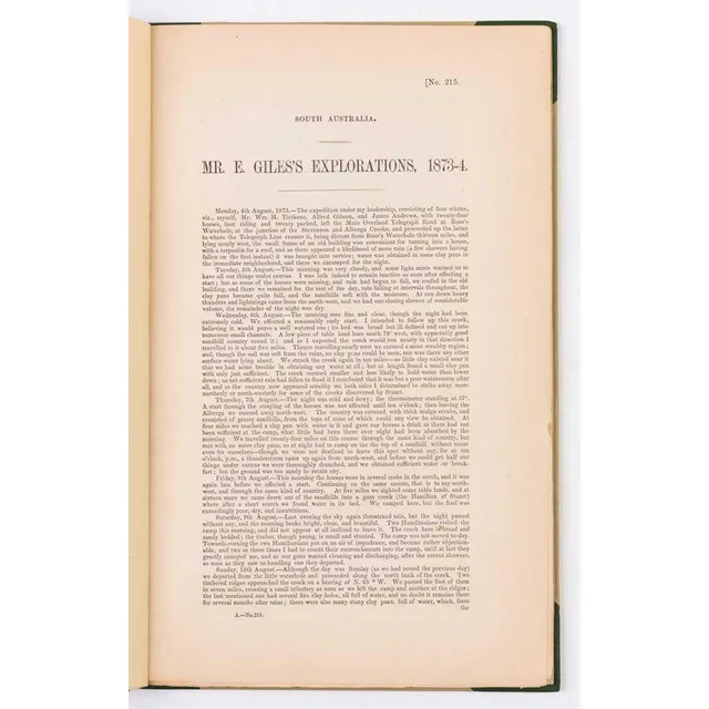
Ernest Giles's Central Australian Explorations, 1873-74
Giles, Ernest. Mr.Ernest Giles's explorations, 1873-74. [Adelaide, 1874]. South Australian Parliamentary Paper, small folio, drop title, pp.70 with folding map, half calf. Some very slight marginal staining at end., The first printing of the great…
![[Gregory]. Papers relating to an expedition recently undertaken…](https://img.carters.com.au/640x640/87a39cefb50eb588489e53cdb710f831.webp)
Exploring Northern Territory of Australia (9 words)
[Gregory]. Papers relating to an expedition recently undertaken for the purpose of exploring the Northern Territory of Australia. London, 1857. British Parliamentary Paper, small folio, pp. [iv], 30 with folding coloured map by Arrowsmith, quarter morocco…

Calvert Expedition, Australia 1896
Hill. J.G., compiler. The Calvert Scientific Exploring Expedition, Australia, 1896. London, 1905. Small quarto, pp. viii, 44, with frontispiece map and large folding map, original cloth., Scarce acount of this disastrous Western Australian expedition led…

Native Tribes of Northern Territory: Introduction & Report
Spencer, W. Baldwin. An introduction to the study of certain native tribes of the Northern Territory. [With] Preliminary report on the Aboriginals of the Northern Territory. Melbourne, 1912-13. Bulletin of the Northern Territory, numbers 2 and 7, quarto,…
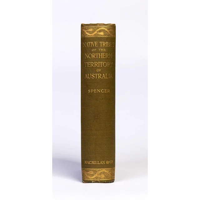
Native Tribes of Northern Territory Australia
Spencer, W. Baldwin. Native tribes of the Northern Territory of Australia. London, 1914. Thick octavo, with folding map and numerous plates, some coloured, original gilt-decorated cloth.
Colonial County Maps of Australia (1848)
Maps (20), various Colonial County Maps. Octavo sized County/Parish maps as pub. 'A Geographical Dictionary or Gazetteer of the Australian Colonies,' W H Wells, published 1848. Boundaries are hand coloured. Majority are NSW, 23 x 15 (paper size)
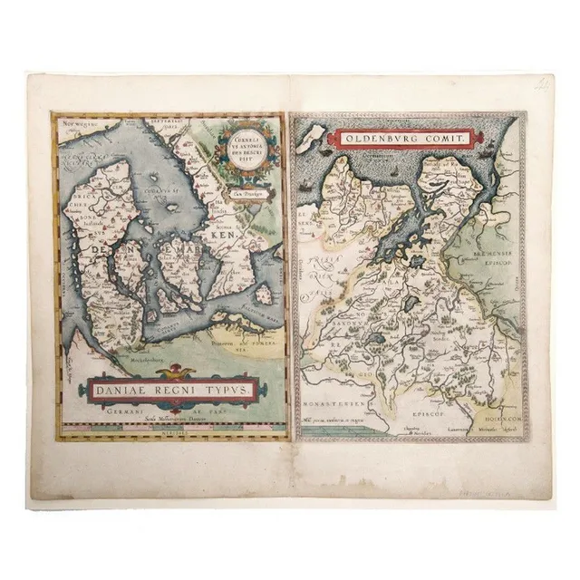
Denmark Maps by Ortelius, Anthoniszoon & Oldenburg, 1598
Map, Ortelius, Daniae Regni Typus. 2 Maps, Denmark by Anthoniszoon & Oldenburg Commit. Pub. By Ortelius, Antwerp, 1598, 35 x 50 cm
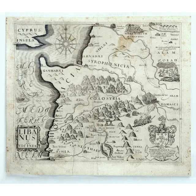
Early Maps of the Holy Land (or) Western Mediterranean Maps
Maps (5) Early Maps of The Holy Land. 5 Maps of Western Mediterranean encompassing modern Palestine, Israel, Lebanon, Jordan & Syria, by Simeoni Bonnell & others. Pub. In A Pisgah-Sight of Palestine and the Confines Thereon by Thomas Fuller, 1650, 29 x 34…
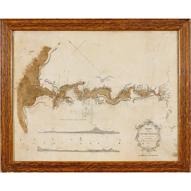
Tamar River Chart with Land Purchased by Meara
Chart of The River Tamar, Van Diemen's Land: corrected from the Best Authorities, D. Allan Lithog., 1833, an Admiralty chart depicting views of Northern Tasmania at the entrance to the Tamar River, 41.5 x 53 cm. Provenance. George Meara (1785-1858).…
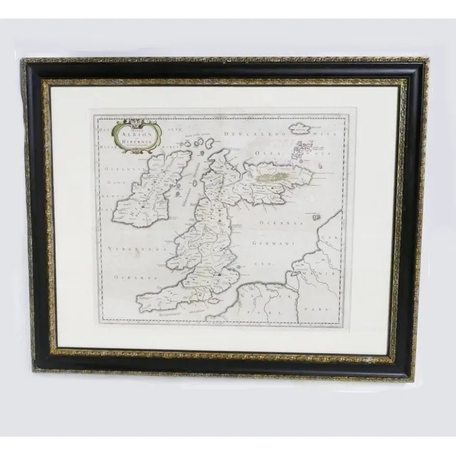
17th Century Hand-Coloured Map of Great Britain by Blaeu
17th century hand coloured map of Great Britain, A c.1654 map of the British Isles entitled 'Insulae Albion et Hibernia cum Minoribus Adjacentibus' by Johanes Blaeu. Original outline colouring. Dutch. 47.5 cm x 60 cm
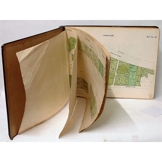
Auckland Fire Brigade Map Folio, 1928
An old 'Auckland Key to Block Plans' folio of street maps in folder form as used by the fire brigade, printed detail including 'Council of Fire & Accident Underwriters Associations of New Zealand in December 1928. Superseding Previous Issue'. 38 cm x 50 cm
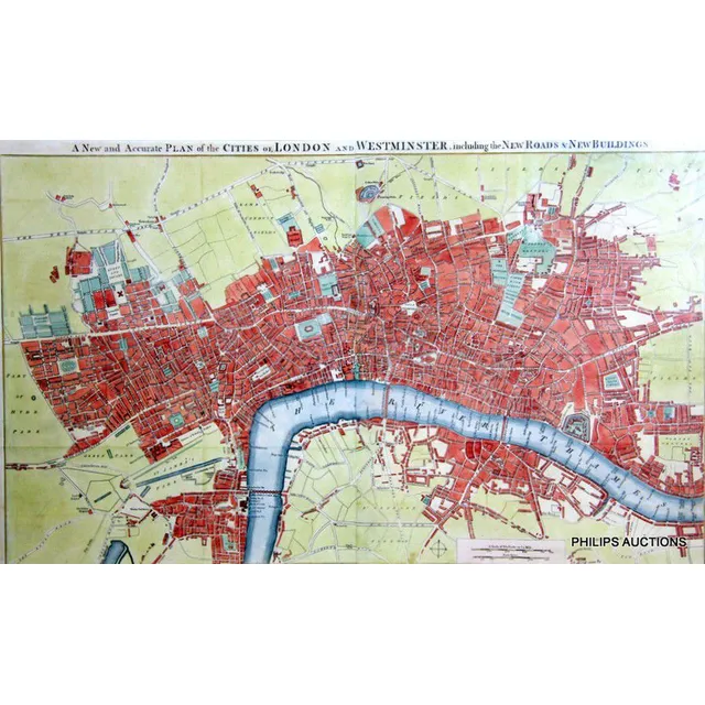
London and Westminster Map, 1754
A new and Accurate plan of the Cities of London and Westminster, including new Roads & new Buildings, circa 1754, the British library collection houses a 1765 version of this map, a fine, rare, hand coloured map marking the various stairways down to the…
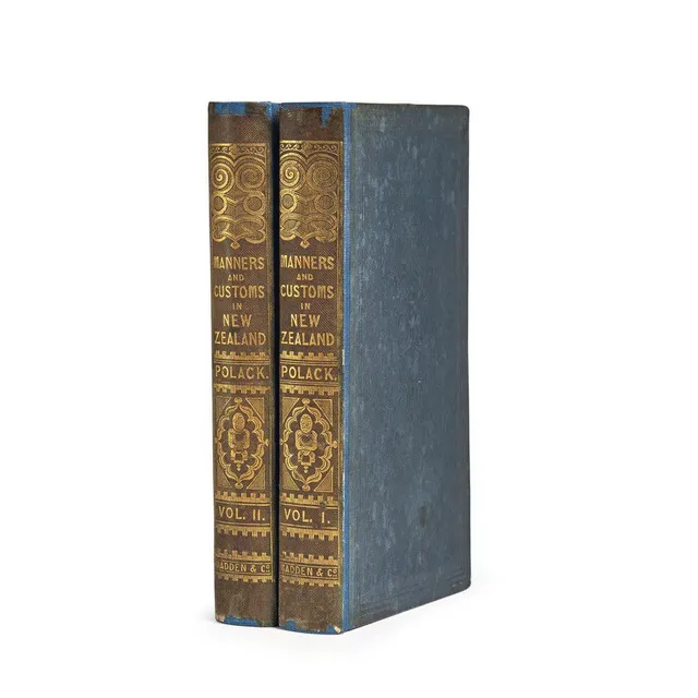
Manners and Customs of New Zealanders
(New Zealand), Polack, Joseph Samuel, Manners and Customs of the New Zealanders, with Notes Corroborative of their Habits, Usages, etc. And Remarks to Intending Emigrants. (London: James Madden && Co. Hatchard & Son, 1840). Two volumes. Small octavo,…
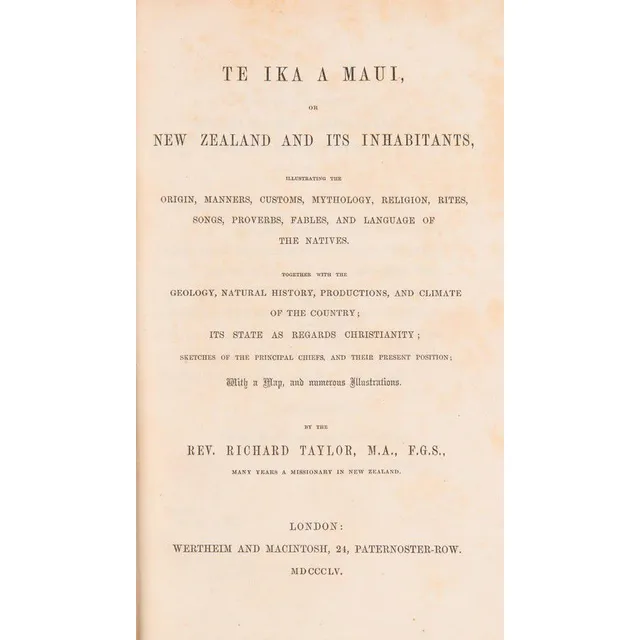
Te Ika A Maui: New Zealand and Its Inhabitants (1855)
(New Zealand) Taylor, Rev. Richard, Te Ika A Maui, New Zealand And Its Inhabitants, (Wertheim and Macintosh, London 1855) Green blindstamped pebbled cloth, gilt lettering on spine, 490 pp. plus 6 pp. publishers ads at rear, brown endpapers. Includes the…
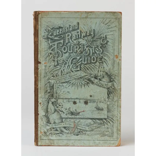
Queensland Railway & Tourists' Guide (1890)
Meston, Archibald (1851-1924), Queensland Railway & Tourists' Guide, compiled under instructions from the Queensland Railway Commissioners. (Brisbane, Gordon & Gotch (1890)). 176p, illustrated with 22 leaves of plates, folding colour map of Queensland…
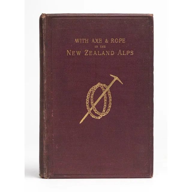
Alpine Adventures in New Zealand
(New Zealand) Mannering, George Edward, With Axe and Rope in the New Zealand Alps. (1st ed. London and New York: Longmans, Green, & Co., 1891). 8vo. viii, 139, 24p. Frontispiece, plates, folding coloured map, publishers? catalogue. Gilt decorated maroon…
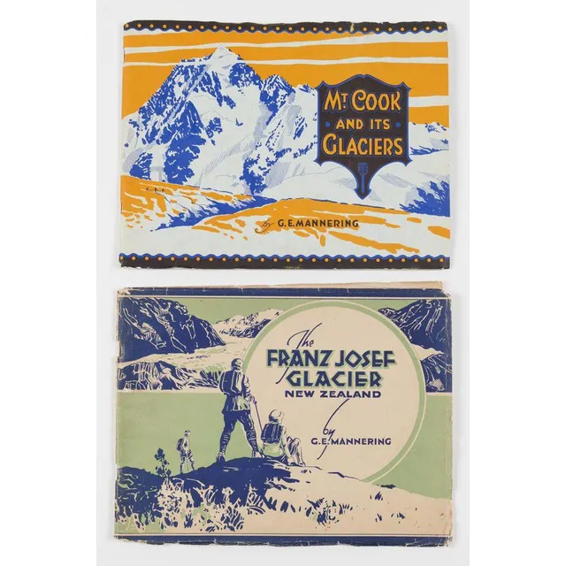
Glaciers of New Zealand by Mannering
(New Zealand) Mannering, George Edward (2 vols.), Mt.Cook and its Surrounding Glaciers (1930) 23 plates, 2 maps, also, The Franz Josef Glacier New Zealand (1931) 23 plates, 1 map. Both with original pictorial paper covers.
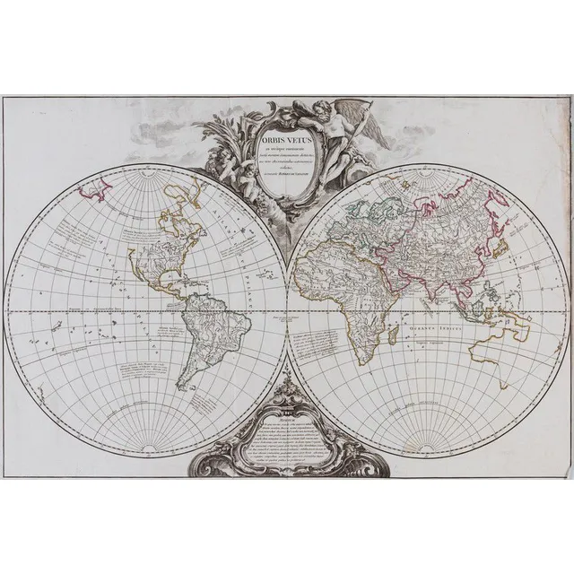
1757 Double Hemisphere World Map with Hypothetical Australia Connection
Vaugondy, Robert de. Orbis Vetus in Utraque Contiente. Paris: c.1757. Double hemisphere world map, with hypothetical east coast of Australia connected to New Zealand and New Guinea. Ornate cartouche above and below. Original outline colour. 50 x 75 cm.…
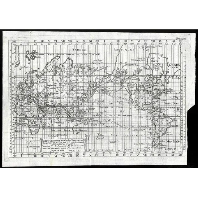
Brouckner/Remondini Map of the World, 1761
Brouckner/Remondini, Carte Generale du Globe Terrestre, Venice, 1761, 25 x 36 cm overall. This uncommon map is Remondini's reduction of Isaak Brouckner's map of the world. It features an extravagant collection of Northwest Passage theories, including one…
Exploration of the South Pacific by European ships
Benard, Robert (Paris, 1774), Carte d'une partie de la Mer du Sud Contenant les Decouvertes de Vaisseaux de sa Majeste: Le Dauphin, Commodore Byron, la Tamar, Capitne Mouats, 1765. Le Dauphin, Capitne Wallis, Le Swallow, Capitne Cartaret, 1767. et…
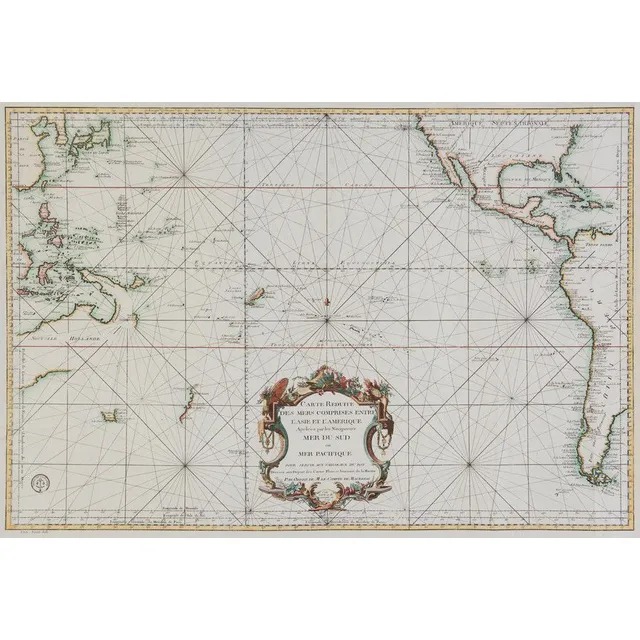
South Pacific and Surrounding Coasts, 1776
Bellin, Jacques Nicolas, 1776, Carte Reduite des Mers Comprises Entre l'Asie et l'Amerique Apelees par les Navigateurs Mer du Sud ou Mer Pacifique.., Paris, 1776, 63 x 89 cm. The chart focuses on the South Pacific, extending to China, Korea & Japan in the…
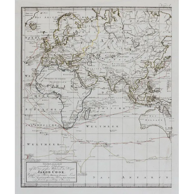
Cook's Three Voyages World Map (9 words)
(World map) Heinrich Robert / F. A. Schraembl, 1789, Generalkarte soemmtlicher Entdeckungen auf den drei Grossen Weltreisen des Kapit Jacob Cook. Two sheets, each 49 x 60 cm to the printed margins. Large world map showing the routes of three voyages made…
New World Chart with British and La Perouse's Tracks
Laurie & Whittle, (London, 1800), A New Chart of the World on Wright's or Mercator's Projection in which are Exhibited all the parts hitherto Explored or discovered with the Tracks of the British Circumnavigators Byron, Wallis, Carteret and Cook, &c. and…
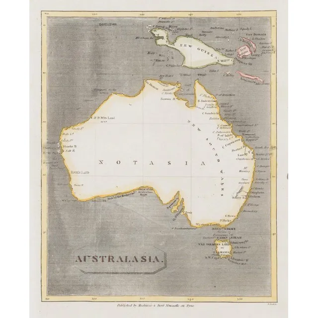
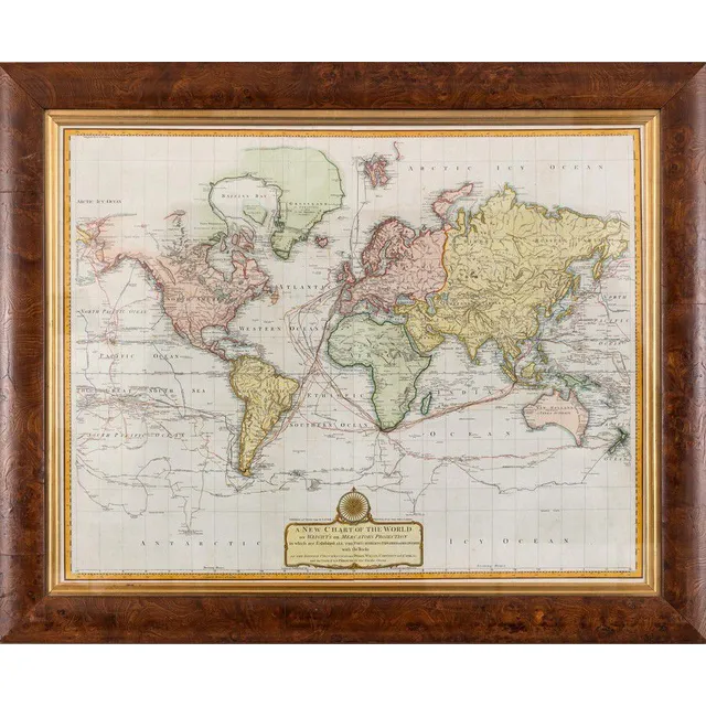
Australasia Map with Notasia and Hypothetical New Guinea
Scott, R. (Mackinzie & Dent, Newcastle on Tyne, Nd but 1811), Australasia, but unlike the earlier c1,800 edition showing the coastline more complete, the map also has 'Notasia' printed in the centre of the landmass. New Guinea and the surrounding islands…
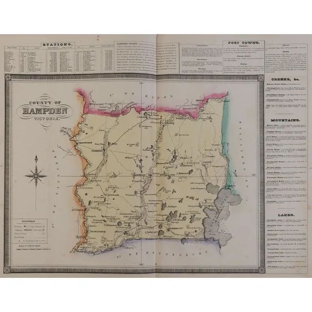
1874 Victorian Counties Atlas with Hand-Coloured Maps
Victoria: Hiscocks, F.E. & Co., publishers. 'F.E. Hiscocks & Co.'s New Victorian, Counties Atlas. Melbourne, 1874'. Folio, title, 5 leaves of letterpress and 22 lithographed maps, hand-coloured, original leather & cloth binding with the original gilt…
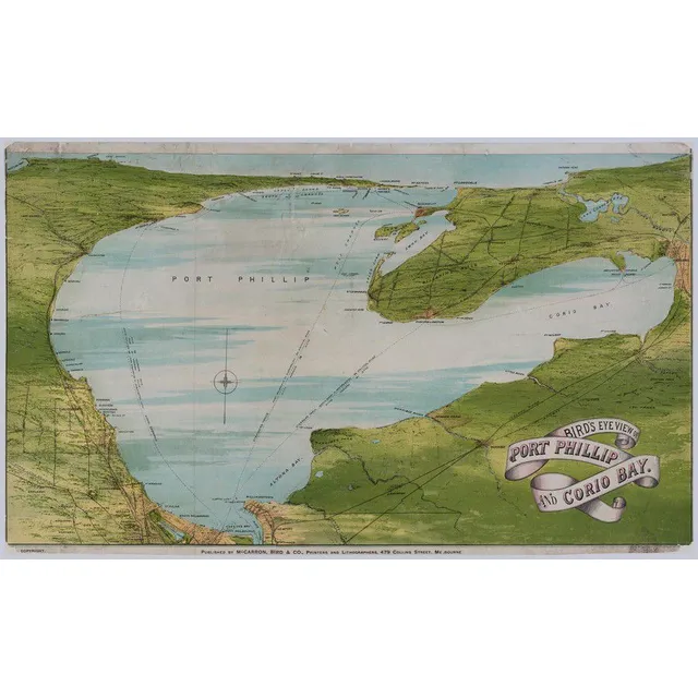
Bird's Eye View of Port Phillip & Corio Bay (1872)
(Victoria) 'Bird's Eye View Of Port Phillip And Corio Bay' 1872, Colour lithograph, title in image lower right, publisher's line in lower margin, 41 x 68 cm. Old folds, scratches and stains, repaired tears and slight paper loss. Linen-backed. 'Published…
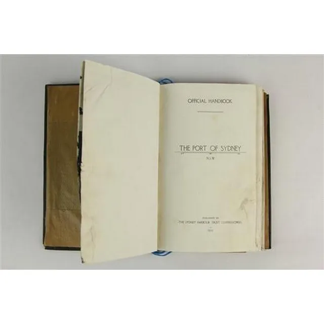
Sydney Port Handbook 1919 with Maps and Dimensions
Port of Sydney NSW official Handbook 1919 published by the Sydney Harbour Trust Comissioners, with various maps, coloured & otherwise, dimensions 22.5 x 15 cm
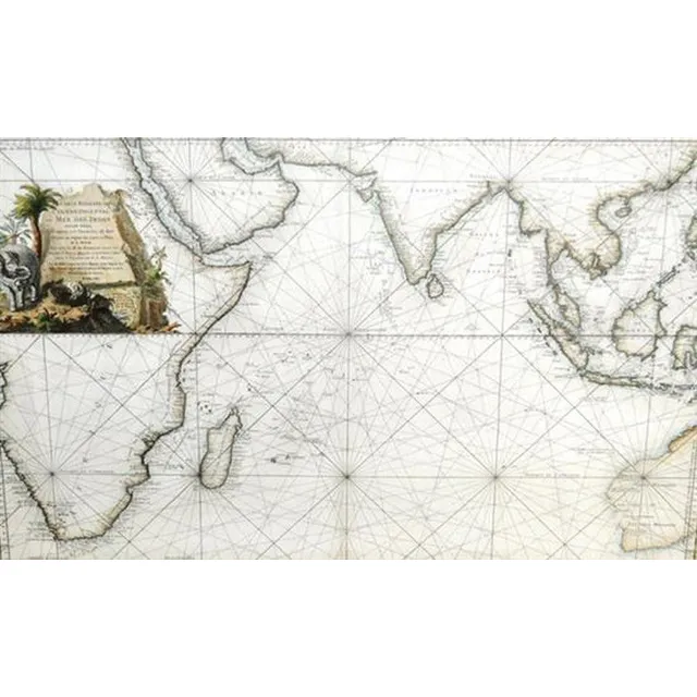
Eastern Ocean Map
After Jacques Nicolas Bellin, (1703 - 1772) France, Map - 'Carte Reduite de L'Ocean Oriental ou mer des Indes, Hand coloured engraving, 57 x 88 cm
Seutter's 17th Century World Map
Matthias Seutter 17th century map, entitles 'Diversi Globi Terr-Aquei Statione Variante et Visu Intercedente, per Ambos Polos et Particul. Sphaerae Zenith in Planum Delineati Orthographici Prospectus, Quibus Additae pro Mutatione Horizontis Differentes…
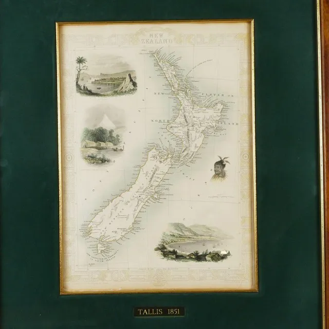
Tallis' Engraved Map of New Zealand (1851)
John Tallis steel engraved map of New Zealand, with hand-coloured outline and vignettes of Auckland, Wellington, Mount Egmont from New Plymouth and a Maori warrior. From 'The Illustrated Atlas and Modern History of the World', pub. London 1851. 26.5 cm x…
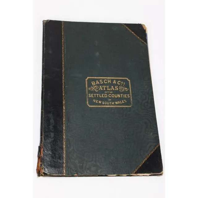
New South Wales Settled Countries Atlas, 1872
Atlas of Settled Countries of New South Wales, by Basch & Co's, featuring twenty maps of the Colony, c.1872
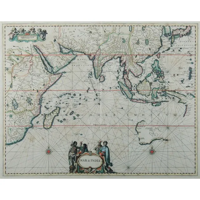
Map of India and Surrounding Regions, 1650
Map, Mar di India, 1650. Cartographer Jansson, showing from cape of good Hope to Korea, including known parts of new Hollande, pub. Amsterdam, 1650, height and coloured copper engraving, 46 x 57 cm
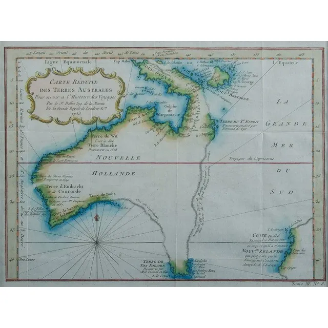
Nouvelle Hollande Map, 1753
Map, Nouvelle Hollande, 1753. Cartographer Bellin, as published in Prevost Histoire Generale des Voyages, Paris, 1753, height and coloured copper engraving, 21 x 28 cm
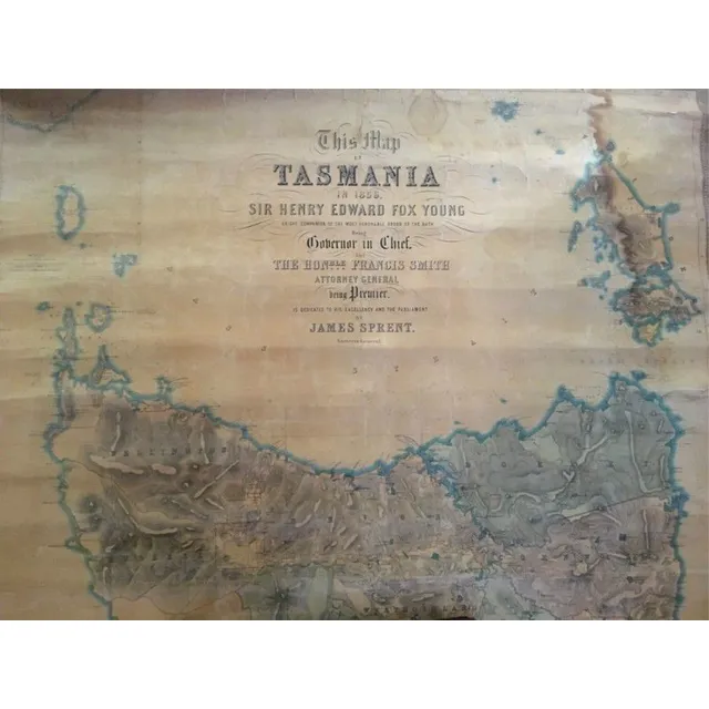
1859 Map of Tasmania by James Sprent
Sir Henry Edward Fox Young, 1859 map of Tasmania by James Sprent (large)
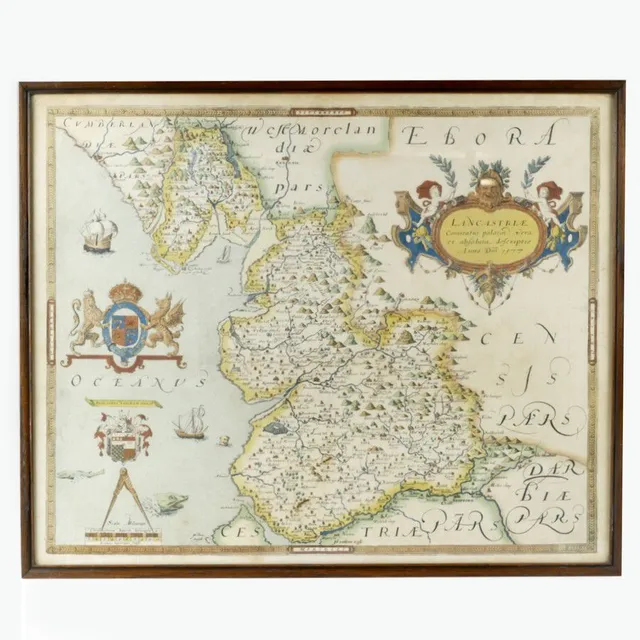
Early English Maps: Saxton and Speed
Two early English maps, one by Christopher Saxton, 'Lancastriae 1577' and 'Chester' by John Speed. Each 42 cm x 53 cm.
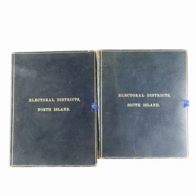
Hand-Coloured Electoral Maps of NZ, c.1907
Two folios of electoral maps of the North and South Islands, hand coloured, sectioned and mounted on fine linen, c.1907. The electoral districts detailed by hand and both with blue Morocco bindings.
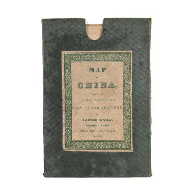
1840 Map of China by James Wyld
Map of China compiled from original survey and sketches by James Wyld, circa 1840, original cloth-backed folding edition in green cloth covered slipcase, 66 cm x 83 cm
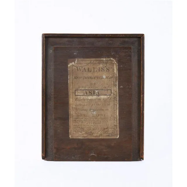
1830 Wallis Map of Asia for Young Students
Circa 1830, 'Wallis's New Dissected Map of Asia Engraved From the Latest Authority For the Use of Young Students in Geography' [J.Wallis, No.42 Skinner St. snow Hill]. Printed lithographic map cut into sections and laid down on interlocking wooden pieces,…
Framed and Mounted Nouvelle Carte Color Maps
Eight framed and mounted colour maps of Nouvelle Carte, three mounted but unframed, framed 46 by 36.5 cm approx.
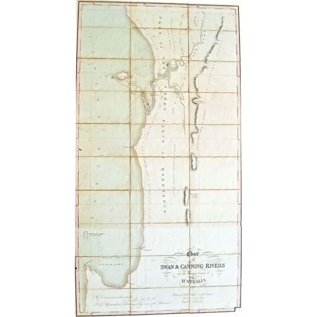
1829 Map of Perth Waters and Swan River
A very early and rare map of Perth Waters Swan Rivers 1829 chart of Swan and Canning Rivers on the west coast of Australia. Published 15 January 1829 by J. Cross of London. Map consisting of cards adhered to fabric backing, framed engraving and hand…
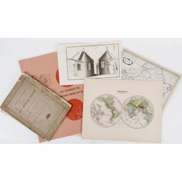
Vintage Visuals: 18th-20th Century Maps, Charts, and Prints
Range of maps, charts, posters, engravings and prints, 18th to 20th century, inspection will reward
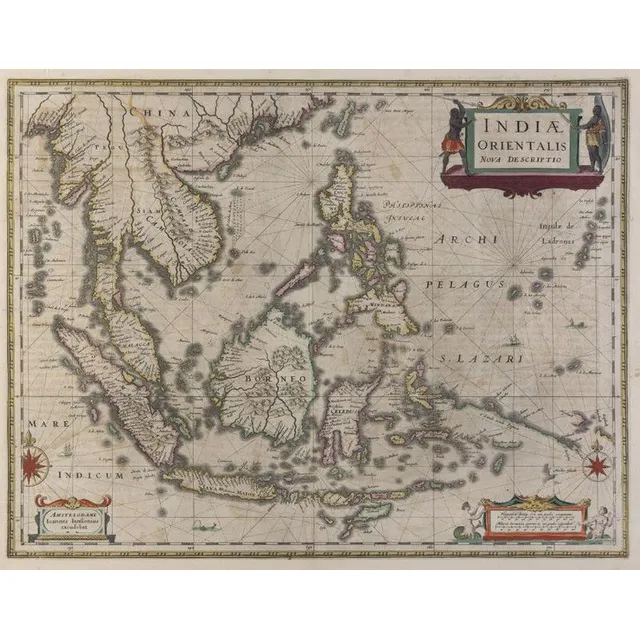
Dutch Map of East Indies and Australia (1630)
Johannes Janssonius (Dutch, 1588- 1664)., Indiae Orientalis, Nova Descriptio, [Dutch Map Of The East Indies] 1630., Copperplate engraving, text including title in plate, overall, 50 x 58 cm (paper). Some hand colouring. Text includes 'Amstelodami. Ioannes…
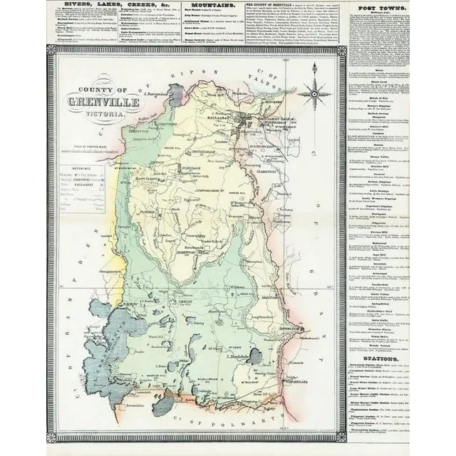
Grenville Victoria County Atlas 1874
County Of Grenville Victoria by F.E. Hiscocks & Co.'s new Victorian counties atlas, circa 1874
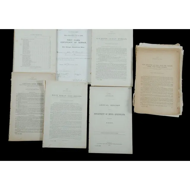
19th Century QLD Mining Reports with Maps and Diagrams
19th century Queensland Mining. Various yearly and district reports, many with folding maps and diagrams. As disbound from Government Gazettes. Spanning 1870 to 1896
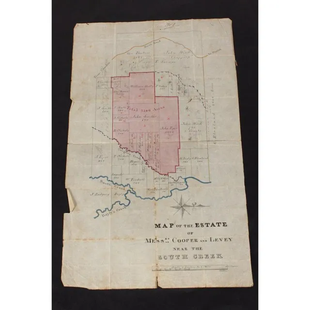
Estate of Copper and Levey Hand-Drawn Map
Australian Colonial hand drawn map of the Estate of copper and Levey, near south creek (Badgery Creek), showing the current landowners such as John Piper and Blaxland and the areas that Cooper and Levey were acquiring, signed P.L Bemi, 42 cm x 26 cm
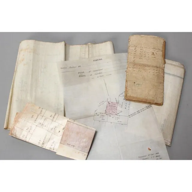
Hand-drawn Colonial Maps of Australia
Five Australian Colonial hand drawn maps, including Rushcutters Bay Act of 1878, sketch of Subdivisions of Francis Giles Point Piper, Divisions beside James Mc Arthurs Moreton Park, 1862 tracing Calderwood and Parish of Wongawilli (5)
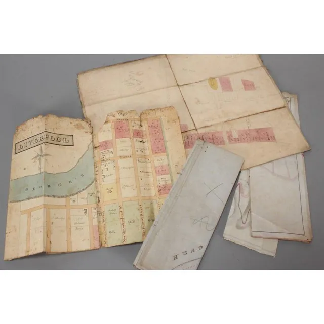
Colonial Maps of Australia
Five Australian Colonial maps, including town plan of Liverpool, 1847 state of Blighs terrace, Subdivision of Lots 26 & 27 Point Piper Estate, plan of land Ownership along Edgecliff Rd and 1895 plan showing alternate roads Macquarie mountain
Assorted Australian and Colonial Maps and Sketches
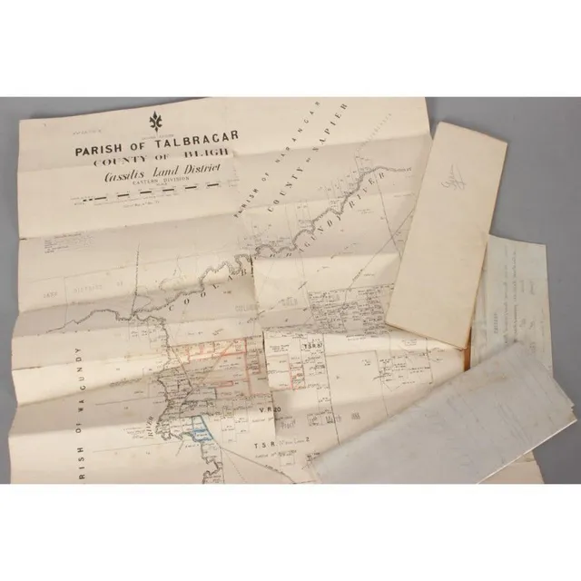
Five Australian and Colonial maps, sketch of Shewing land in the Parish of Calderwood, tracing of Parish Calderwood Camden, print of Parish of Gyan, Parish of Talbragar County Bligh and plan of intersection of Parramatta Rd Northuberland Ave and Johston…
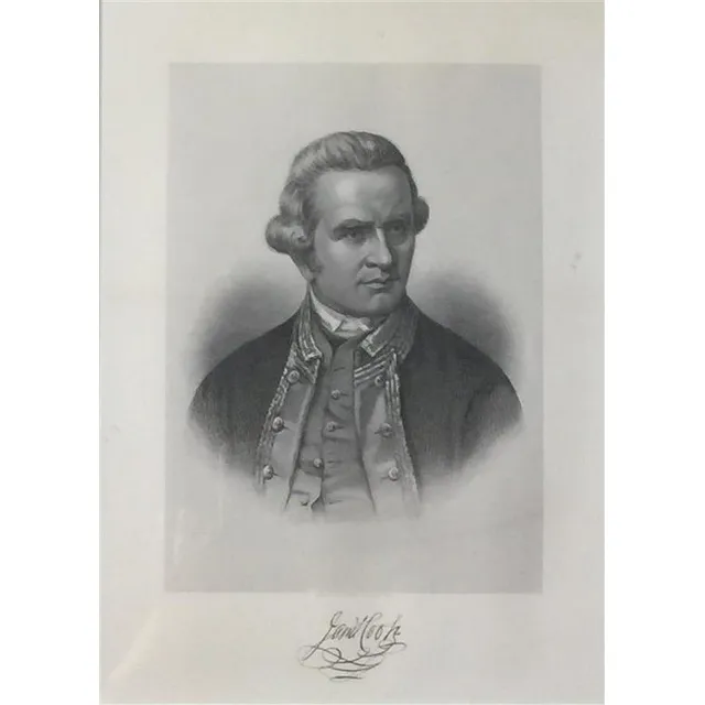
Nathaniel Dance's Portrait of James Cook Engraving
After Nathaniel dance, (1735-1811), James Cook, steel engraving, eng. Hb Hall's Sons, New York, facsimile signature below image, from Picturesque atlas of Australasia, original in National maritime Museum, Greenwich, 25.5 x 18 cm
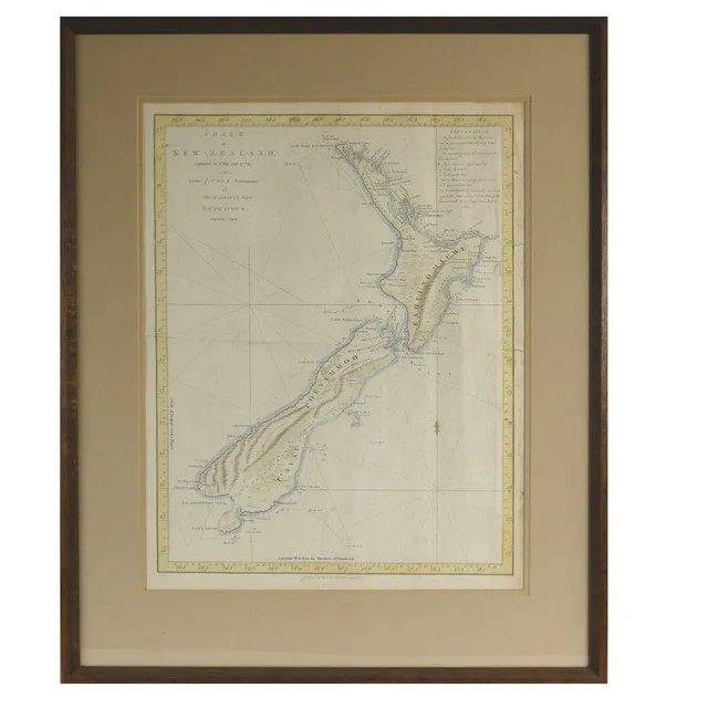
Cook's 1772 Chart of New Zealand
James Cook 'Chart of New Zealand...', rare original 1772 engraving by John Bayly from the official first edition Hawkesworth publication of Cook's Voyage. hand coloured in outline. 49 cm x 38 cm. The first complete coastline chart of all New Zealand,…
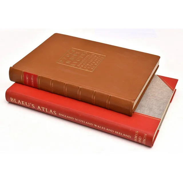
Limited Edition Atlases: Ptolemy & Blaeu
Ptolemy's Geographica, 1974 & Blaeu's Atlas of England, Scotland, Wales and Ireland; Ptolemy's Geographica, full leather binding. Limited edition no. 40 of 250, signed by the Lord Major of Plymouth, England. Blaeu's atlas of England, Scotland, Wales and…
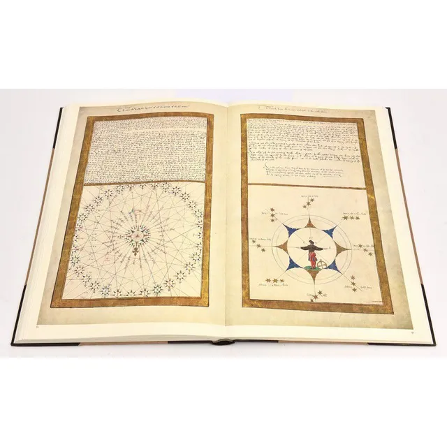
Rotz Atlas: 1542 Cartography for King Henry VIII
The Rotz Atlas; the maps and text of the Boke of Idrography presented in 1542 by Jean Rotz to King Henry VIII. Published by the Roxburghe club, 1981. Half leather binding with linen boards.
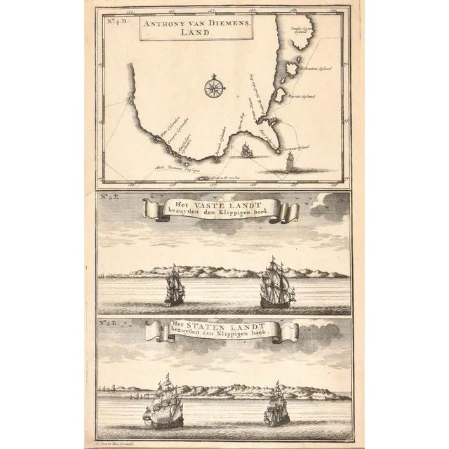
Early Map of Tasmania and Abel Tasman's Voyage
Anthony van Diemens Land; Francois Valentijn, Amsterdam, circa 1726; an early map of Tasmania showing the track of Abel Tasman's epic first voyage of 1642-1643, which resulted in the discovery of Tasmania and New Zealand. 19 cm x 30 cm
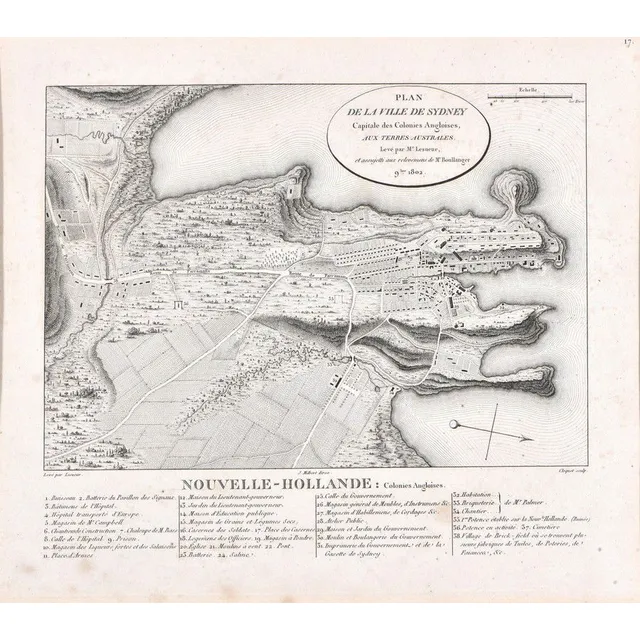
Sydney City Plan, 19th Century Engraving
Plan De La Ville De Sydney; after Charles Alexander Lesueur, France, early 19th century; engraving. Foxing in places; 25.5 cm x 22 cm
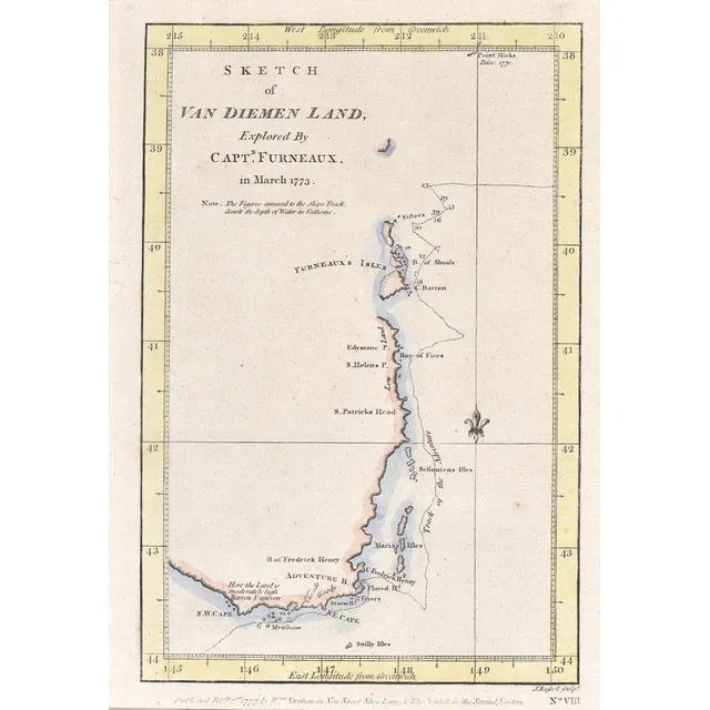
First British Map of Tasmania, 1777
Sketch of van Diemen land; Strahan & Cadell, London, 1777; Explored by Captain Furneaux in March 1773, hand coloured. Being the first British chart of Tasmania. 23 cm x 16 cm
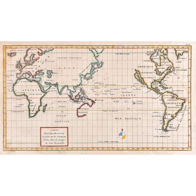
Centurion's Route Map, France 1787
Carte Dans Laquelle on Voit La Route Que Le centurion a Tenu; Jean Lattre, France, circa 1787; hand coloured copper engraving. 42 cm x 23 cm
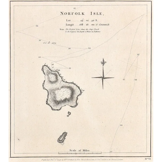
Norfolk Isle Map, 1777
A map of Norfolk Isle; Strahan & Cadell, London, 1777; the engraved nautical chart, published in Cook's a voyage towards the south pole, and round the world. 20 cm x 33 cm
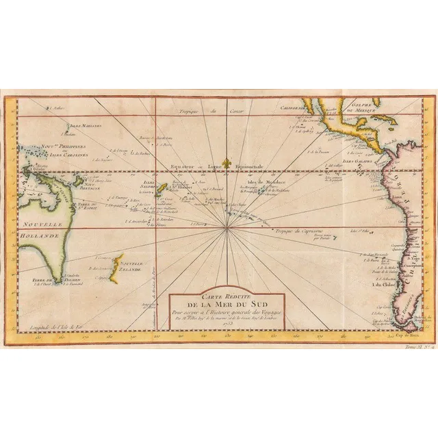
Reduced Map of the South Pacific
Carte Reduite De La Mer Del Sud; Jacques Nicolas Bellin (1703-1772), Paris, circa 1753; the hand coloured early map of Australia and New Zealand. 36 cm x 21 cm