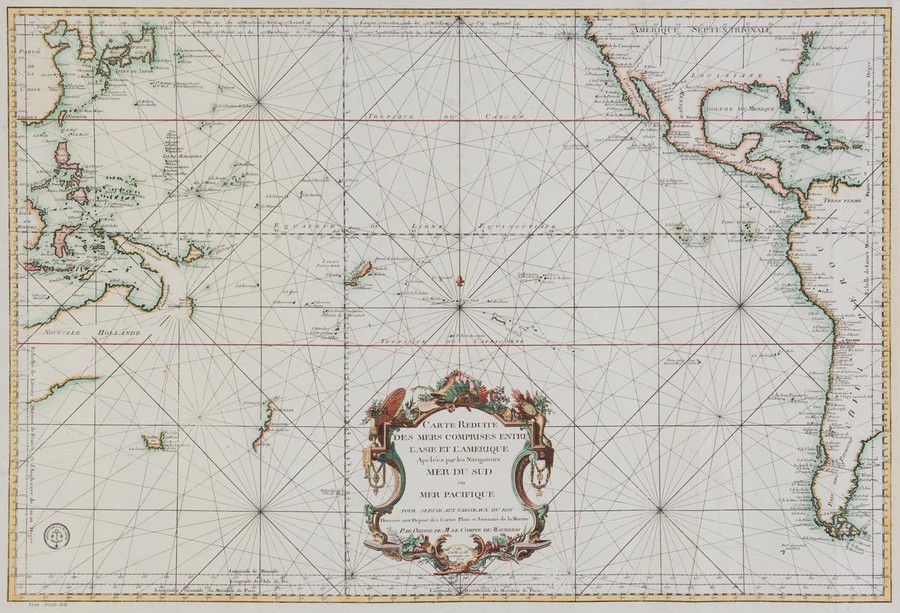
Bellin, Jacques Nicolas, 1776, Carte Reduite des Mers Comprises…
click the photo to enlarge
Bellin, Jacques Nicolas, 1776, Carte Reduite des Mers Comprises Entre l'Asie et l'Amerique Apelees par les Navigateurs Mer du Sud ou Mer Pacifique.., Paris, 1776, 63 x 89 cm. The chart focuses on the South Pacific, extending to China, Korea & Japan in the northwest and to Virginia and California in the northeast. Place names are given along the coasts, while the interiors are left almost entirely blank. This map was published after Captain Cook's second voyage and includes depictions of the western coast of New Zealand, the northern coastline of Australia, and portions of New Guinea. Tasmania is shown with a dotted conjectural coastline connecting it to Australia.

You must be a subscriber, and be logged in to view price and dealer details.

Subscribe Now to view actual auction price for this item

When you subscribe, you have the option of setting the currency in which to display prices to $Au, $US, $NZ or Stg.

This item has been sold, and the description, image and price are for reference purposes only.

This item has been included into following indexes:

Visually similar items

'Carte De La Nouvelle Zeelande'. By M. Bonne. Hand coloured. 37 x 25 cm

Sold by in for
You can display prices in $Au, $US, $NZ or Stg.

Map, Mar di India, 1650. Cartographer Jansson, showing from cape of good Hope to Korea, including known parts of new Hollande, pub. Amsterdam, 1650, height and coloured copper engraving, 46 x 57 cm

Sold by in for
You can display prices in $Au, $US, $NZ or Stg.

Lionel Lindsay (Australia,1874-1961), etching limited edition. Titled 'Summer moon', signed lower left. Image size approx 18 by 23 cm

Sold by in for
You can display prices in $Au, $US, $NZ or Stg.

An 18th century map 'Part of Sussex' by Robert Morden, hand coloured in outline. 36 cm x 41 cm

Sold by in for
You can display prices in $Au, $US, $NZ or Stg.