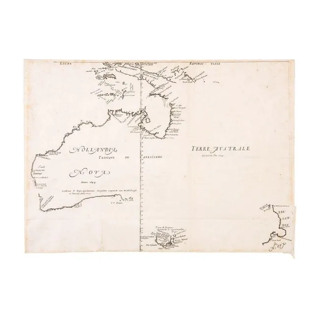
First Map of Australia, 1644
First Large-Scale Map of the Australian Continent 'Hollandia Nova detecta 1644, Terre Australe decouverte l'an 1644' by Melchisedech Thevenot [Paris, 1644]. The very rare first issue in its first state: with the latitudes incorrectly numbered, without the…
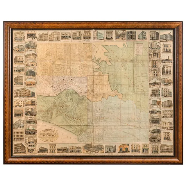
1872 Illustrated Map of Melbourne and Surrounding Businesses
'Illustrated Map of Melbourne and Suburbs Showing Government Sections and Allotments, Railways, Public Buildings, &c. Compiled from the latest Surveys and most authentic Sources to date. Published by Chas. F. Maxwell and W. Reed Phillips, 74 Chancery Lane…
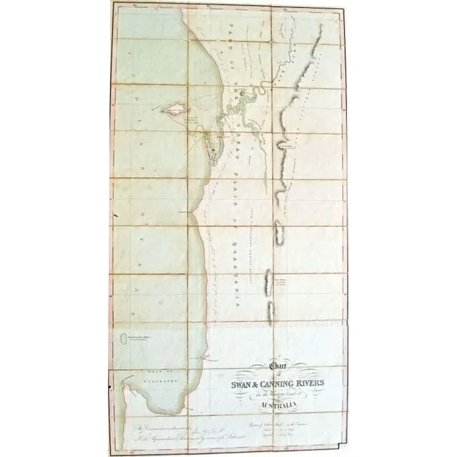
1829 Map of Perth Waters and Swan River
A very early and rare map of Perth Waters Swan Rivers 1829 chart of Swan and Canning Rivers on the west coast of Australia. Published 15 January 1829 by J. Cross of London. Map consisting of cards adhered to fabric backing, framed engraving and hand…
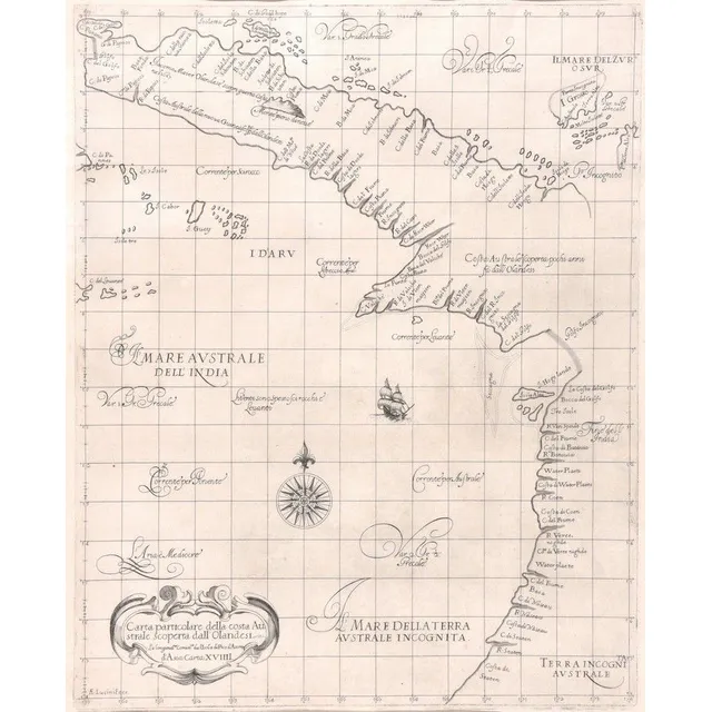
Coastal Map of Northeast Australia by Cocchini
Carta Particolare Della Costa Australe Scoperta Dall'Olandesi, Giuseppe Cocchini, Florence, 17th century; the uncoloured engraved map showing the northeast coast of Australia. 39 cm x 46 cm
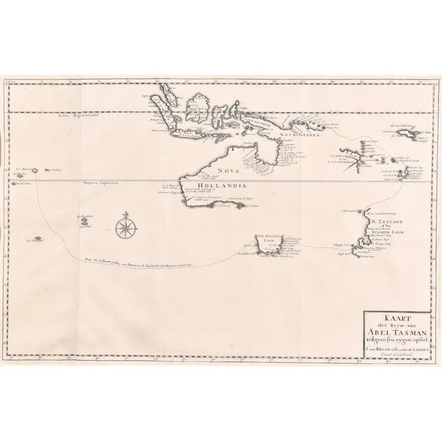
Abel Tasman's Discoveries in Australasia, 1642-1644
Kaart Der Reyse van Abel Tasman; Francois Valentijn (1666-1727), Amsterdam, 1726; Uncoloured map from Vol III, 2 of Valentijn's 'Old and New East India' detailing the discoveries of Abel Tasman in Australasia during the course of his two voyages of 1642 &…
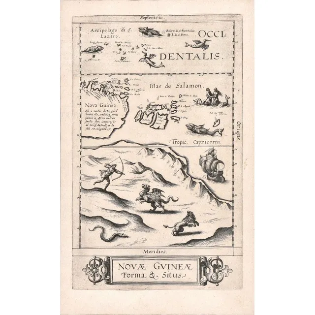
First Printed Map of Australia: Nova Guinea Forma & Situs
Nova Guinea Forma & Situs; Cornelis De Jode (1568-1600), Antwerp, 1593; the rare uncoloured map of New Guinea, is recognised as the first printed map of Australia. The whole of the lower half of the map depicts an entirely imaginary northern coast of…
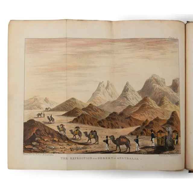
Plan for Exploring and Surveying Australia's Interior
Maslen, T.J., the friend of Australia, or, a plan for Exploring the interior, and for carrying on a survey of the Whole Continent of Australia. By a Retired Officer of the Hon. East India Company's service. Illustrated with a map of Australia, and five…
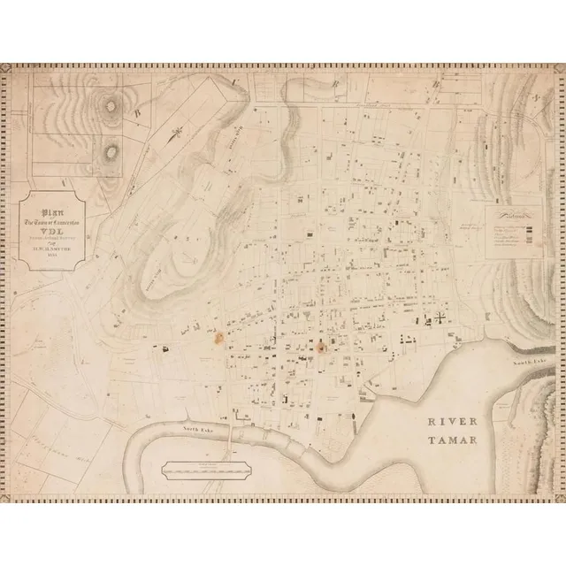
Launceston Town Map, Van Diemen's Land, 1855
A colonial surveyor's map, 'Plan of the town of Launceston, Van Diemen's Land, from the actual survey by H. W. H. Smythe, 1855', 64 cm high, 78 cm wide
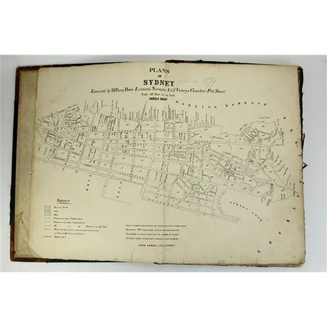
Sydney Plans 1880: Detailed Hand-Coloured Lithographs
John Sands 'Plans of Sydney By Executed H. Percy Dove' Licenced Surveyor 1 & 2 Vickerys Chambers Pitt Street. Scale 40 feet to an inch. Totaling ninety-six hand coloured lithographed pages on inner Sydney circa 1880. the first, unnumbered, map on the…
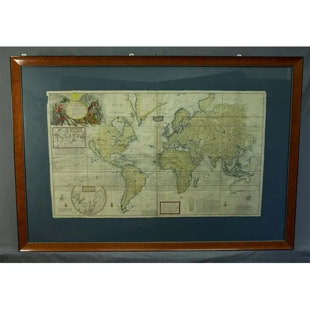
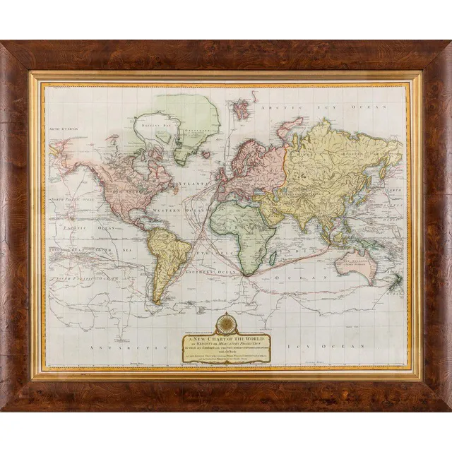
Herman Moll's 1719 World Map
Map, New & Correct Map of the Whole World. Made or published by Herman Moll, London, 1719. Four joined sheets, hand coloured. Various repaired tears & small losses to the margins. 73 x 123 cm
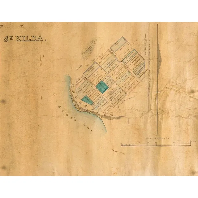
St Kilda, Victoria Map, 1840
A map of St Kilda, Victoria, c. 1840, lithograph with watercolour highlight on paper backed on linen, 30 x 36.5 cm
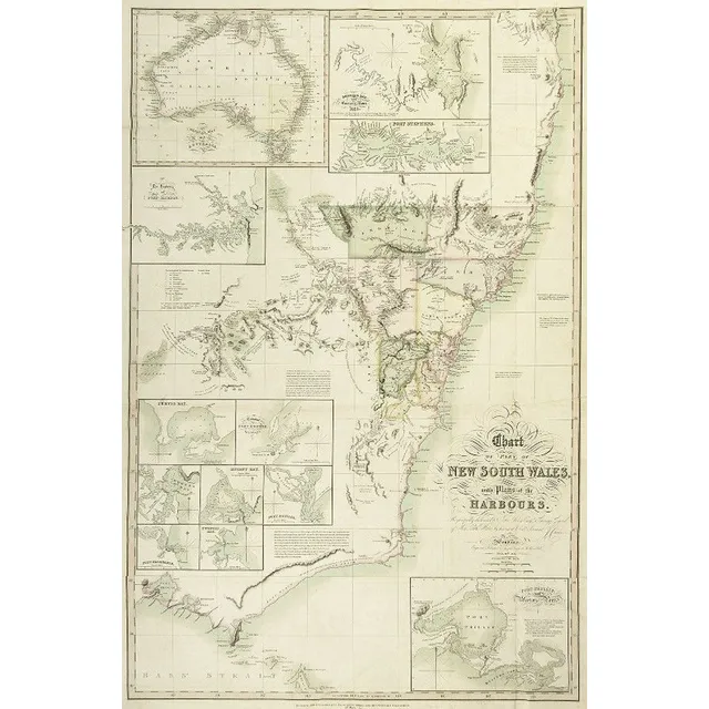
1827 New South Wales Chart with Harbour Plans
1827 Chart of part of New South Wales, with Plans of the Harbours. This is the 1828 issue, engraved & published by Joseph cross, London. Hand coloured engraving. 97 x 65 cm
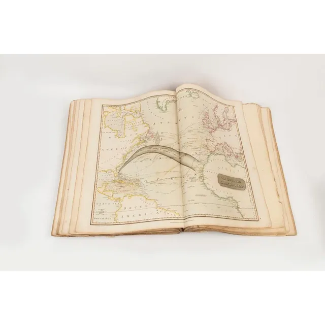
Thomson's General Atlas 1817: Natural & Political Divisions
John Thomson (Scottish, 1777-C1840), a new general atlas 1817, a collection of maps and charts delineating the natural and political divisions of the Empires, Kingdoms, and States in the world, printed by George Ramsay and Company for John Thomson and…
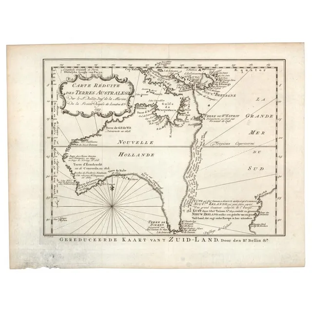
1758 Dutch Edition Map of Hypothetical East Coast Australia
Jacques Bellin: 'Carte Reduite Des Terres Australes, Par le Sr Bellin....', (Paris, 1753), lovely map showing hypothetical East coast of Australia, being the Dutch edition of 1758, 36 x 25 cm. This Dutch edition, published in 1758, is scarcer than its…
East India & Australia Map c.1700 by van Kenlen
Map, East India & Australia c1700. Africa to Japan incl. Australia. Made by van Kenlen, Amsterdam. Staining, watermarks & a few holes near the margins. Rebacked. Hand coloured engraving. 53 x 6 0 cm
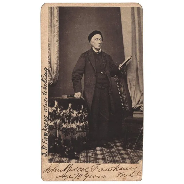
Fawkner Signed Carte de Visite with News Clipping
John Pascoe Fawkner signed carte de visite with inscription verso and accompanying news clipping and envelope,
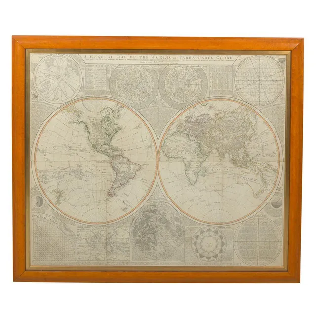
Samuel Dunn's Terraqueous Globe, 1799
A general map of the world, or Terraqueous globe, by Samuel Dunn, Published by Laurie & Whittle, no. 63 Fleet St, London, 12th May 1799. Hand coloured and printed on four sheets, joined. Glazed and framed in cedar. 102 cm x 124 cm
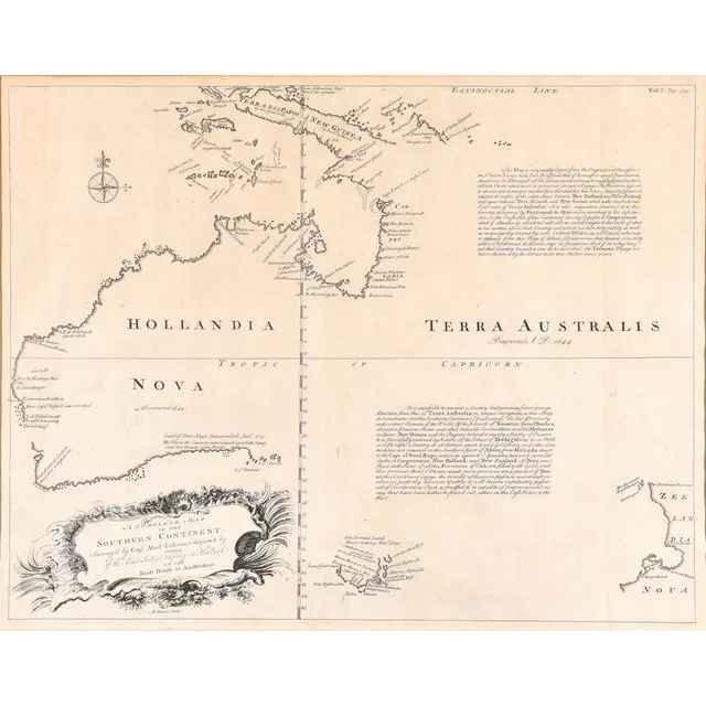
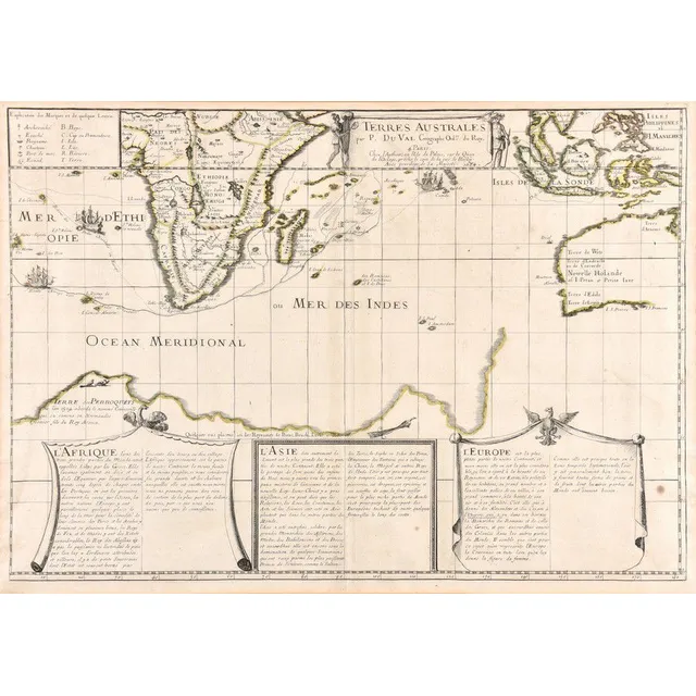
Southern Continent Map by Emanuel Bowen (1744)
A complete map of the Southern Continent; Emanuel Bowen (1693-1767), London, 1744; the uncoloured map, surveyed by Capt. Abel Tasman & depicted by order of the East India Company in Holland in the Stadt house at Amsterdam, being the first English map of…
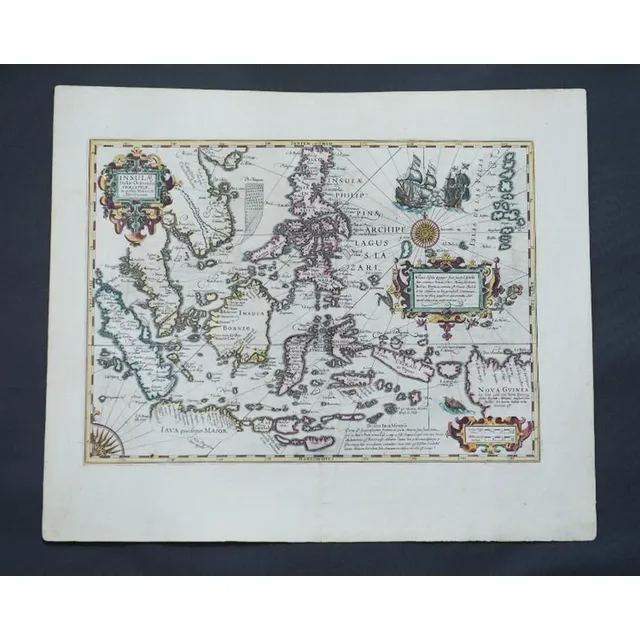
Eastern Islands of Moluccae
Map, Insulae Indaie Orientalis in Quibus Moluccae Celeberrimae Sunt. Mapmaker Hondius, pub. Amsterdam 1613. Hand coloured engraving. 35 x 4 8 cm
Van Diemen's Land Chart, 1824
Chart of Van Diemen's Land, From the Best Authorities, and From Actual Surveys and Measurements', by Thomas Scott (Edinburgh, 1824), (tear at base), impressive musk wood frame, 62 x 87 cm overall. (Tooley 1129). Provenance: Property originally of Thomas…
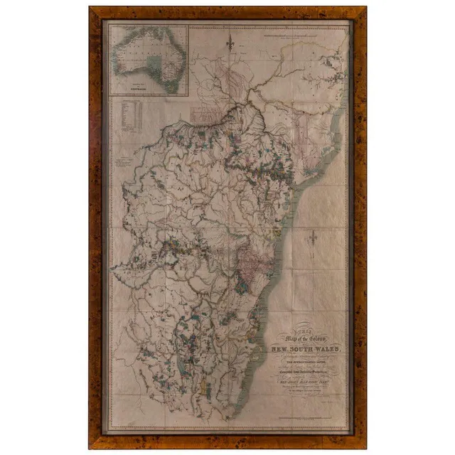
Detailed Map of New South Wales, 1837
Dixon, Robert., This Map of the Colony of New South Wales, Exhibiting the Situation and Extent of The Appropriated Lands, including the Counties, Towns, Village-Reserves, &c Compiled from Authentic Surveys &c. is respectfully Dedicated to Sir John Barrow…
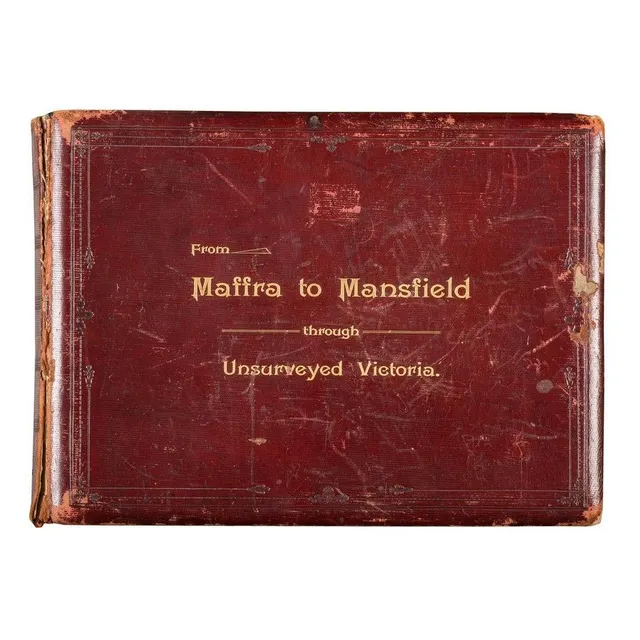
Unsurveyed Victoria: A Horseback Journey in 1890
From Maffra to Mansfield Through Unsurveyed Victoria, A fine, leather bound album with gold embossed title to front cover, circa 1890, with printed title page followed by a tipped-in map showing the route of a survey conducted on horseback with the…
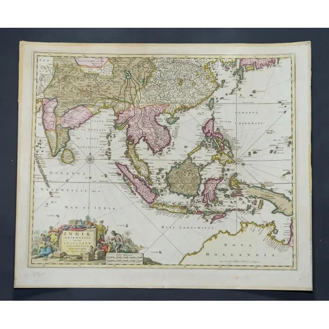
India and Adjacent Islands Map by Blaeu, c.1635
Map, India Quae Orientalis et Insulae Adiacinte. Mapmaker, Willem Janszoon Blaeu, c.1635. Engraving. 43 x 5 2 cm
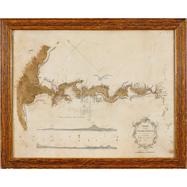
Tamar River Chart with Land Purchased by Meara
Chart of The River Tamar, Van Diemen's Land: corrected from the Best Authorities, D. Allan Lithog., 1833, an Admiralty chart depicting views of Northern Tasmania at the entrance to the Tamar River, 41.5 x 53 cm. Provenance. George Meara (1785-1858).…
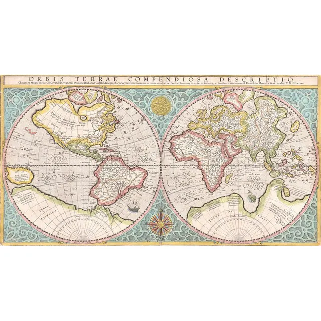
Mercator's 1587 Double-Hemisphere World Map
World map, Orbis Terrae Compendiosa Descriptio. Rumold Mercator (1545-1599), dated 1587 (circa 1619); engraved & coloured double-hemisphere world map,; 52 x 28 cm
Bishop Patteson's Rare Map of Australasia, 1859
Bishop John Coleridge Patteson's personal copy of the rare 'Stanford's map of Australasia, London: Edward Stanford, 1859. First edition. Steel engraved map with hand colouring, total 155 cm x 174 cm, dissected into 48 sections, laid onto linen edged with…
Cook's 1772 Chart of New Zealand
James Cook 'Chart of New Zealand...', rare original 1772 engraving by John Bayly from the official first edition Hawkesworth publication of Cook's Voyage. hand coloured in outline. 49 cm x 38 cm. The first complete coastline chart of all New Zealand,…
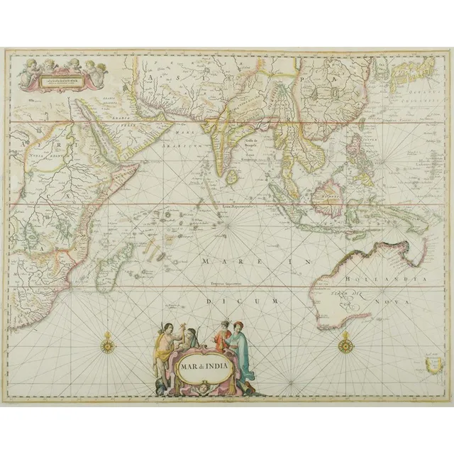
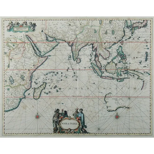
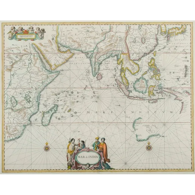
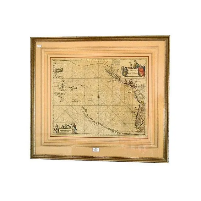
"Mar Di India" Map, 1659
Map, 'Mar Di India,' 1659. Cartographer Johannes Janssonius 1588-1664). 43 x 54 cm
Cook's Discoveries: General Chart and Ship Tracks
A selection of bound maps; including a general chart: exhibiting the discoveries made by Captain. James Cook in this and his two preceding voyages; with the tracks of the ships under his command.
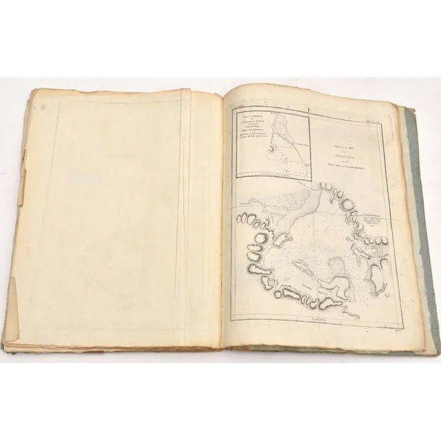
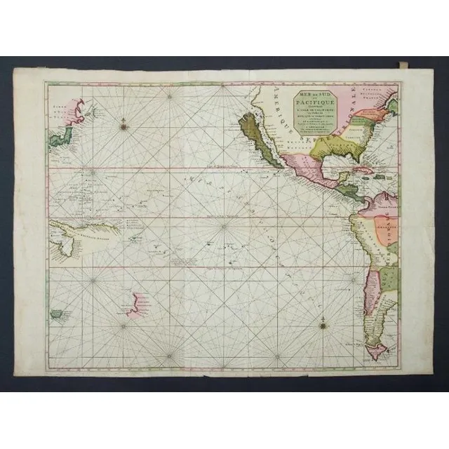
Pacific Map by Coronelli, 1691
(Parte Del Mare Pacifica), engraved by Vincent Mario Coronelli (Theologian, Mathematician & Cartographer, Venice), 1691. 46.5 x 61.5 cm (plate size), finely executed copperplate-engraved map with some sensitive hand-colouring showing the west coast of…
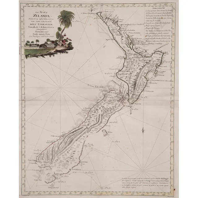
Hand Coloured Map of New Zealand by Antonio Zatta
Antonio Zatta La Nuova Zelanda hand coloured map with title vignette upper left, published Venice 1778, 47 x 37.5 cm
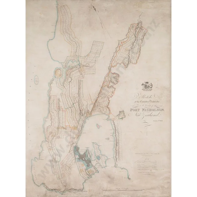
Surveyor's Map of Port Nicholson, New Zealand (1843)
Samuel Charles Brees (Chief Surveyor) sketch of the country Districts in the Vicinity of port Nicholson New Zealand January 4th 1843 (London) hand coloured engraving, published Smith & elder & Co, Cornhill Oct 2nd 1843, 76 x 57.5 cm
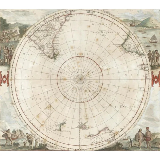
Antarctic Region Map with Tasman's Discoveries
De Wits edition of the Hemispherical map of the Antarctic Region by Hondius, 1680, originally published by Hondius, 'Polus Antarcticus' went through several changes. This edition shows Tasman's discoveries from his 1st voyage in Australia and New Zealand.…
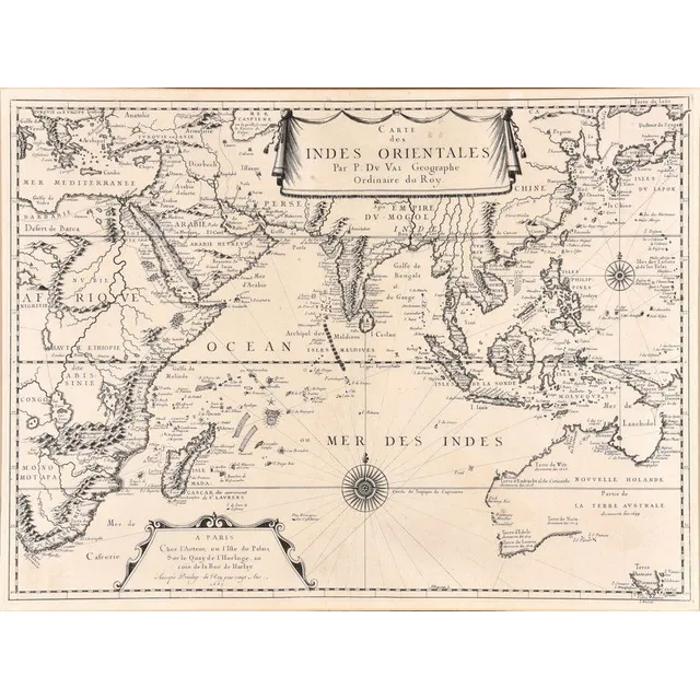
Indian Ocean Map with Abel Tasman's Voyages
Carte Des Indes Orientales; Pierre du Val (1618-1683), Paris, 1665; the uncoloured map of the Indian Ocean, featuring the explorations of Abel Tasman, derived from his voyages to Australia and New Zealand, from 1642 to 1644; 55 cm x 41 cm
Map of India and Surrounding Regions, 1650
Map, Mar di India, 1650. Cartographer Jansson, showing from cape of good Hope to Korea, including known parts of new Hollande, pub. Amsterdam, 1650, height and coloured copper engraving, 46 x 57 cm
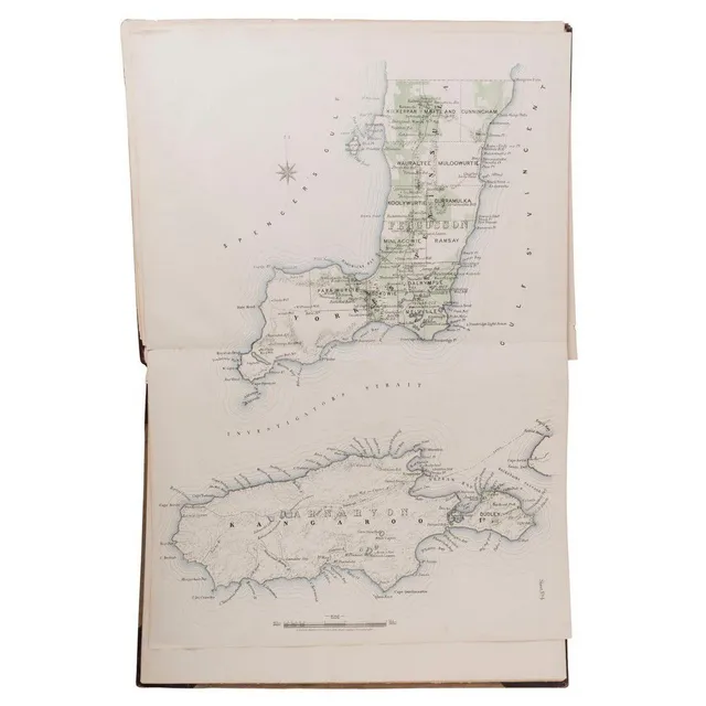
South Australia County and Hundred Atlas (1877)
Atlas, plan of the Southern portion of the Province of South Australia as divided into Counties and Hundreds, compiled from official documents (Surveyor General's office, Adelaide 1877) comprising a key map and 17 double spread maps, bound in half leather
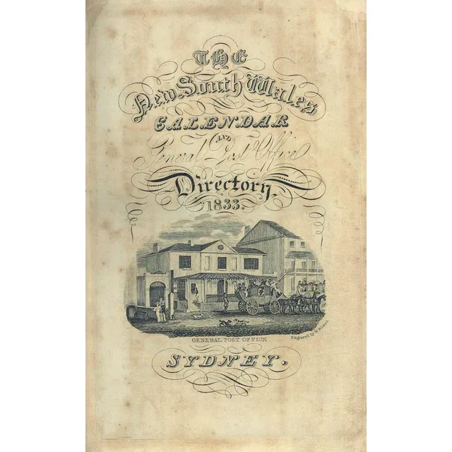
1833 NSW Calendar & Directory with Mitchell's Blue Mountains Pass
Stephens & Stokes: 'New South Wales Calendar and General Post Office Directory, 1833.' [Sydney: December, 1832.] with folding map, engraved title-page with view of the GPO, two folding tables, two folding plates (one hand-coloured), map of Mount Victoria,…
Rare Ottoman Hand-Coloured World Map from 1803
A very rare ottoman hand-coloured world map from the 'Cedid Atlas' (Atlas-i Cedid), the first published atlas in the Muslim world, printed and published in Istanbul, 1803. Based on late 18th century European world maps it details Cook's three voyages of…
Mar Di India Map (1650)
Map, 'Mar Di India,' 1650. Cartographer Johannes Janssonius 1588-1664). 43 x 55 cm
Tallis' Illustrated Atlas with 78 Engraved Maps
World: John Tallis: 'Wrights Universal Dictionary - Atlas' [London, c1852-56], with 78 double-page maps by Tallis with decorative borders & vignette illustrations, engraved maps with original hand-coloured outlines, each c27 x 35 cm, occasional slight…
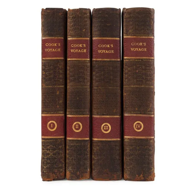
Cook & Forster's Voyage around the World (1777)
Cook, James & Forster, George, a voyage round the world Performed in his Britannic Majesty's ships the Resolution and adventure, in the Years 1772, 1773, 1774, and 1775....Illustrated with a chart of the Southern Hemisphere...[Dublin, W.Whitestone, S…
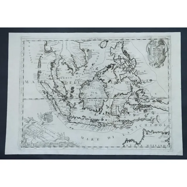
Indonesia, Australia & Philippines Map by Coronelli (c1690)
Map, c1690 Indonesia, Australia & Philipines. Mapmaker Vincenzo Maria Coronelli, 'Isole Dell' Indie diuise in Filippine, Molucche e della Sonda. Pub. Venice. Engraving. 47 x 6 2 cm
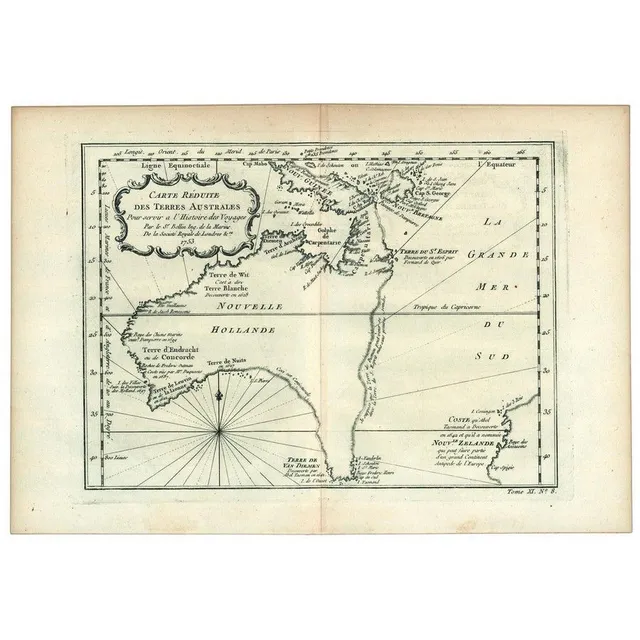
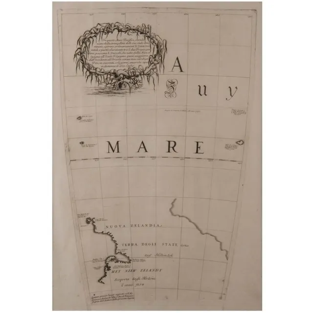
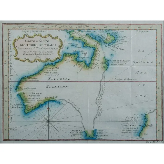
Hypothetical East Coast of Australia, 1753
Carte Reduite Des Terres Australes, Pour servir a l'Histoire des Voyages' by Jacques Bellin, [Paris, 1753], lovely map showing hypothetical east coast of Australia, 36 x 25 cm.
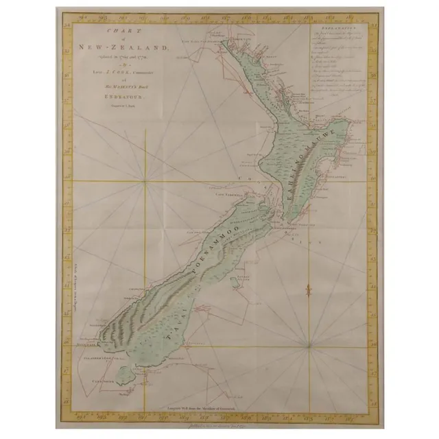
Cook's 1770 Chart of New Zealand
'Chart of New Zealand Explored in 1769 and 1770'. By Lieutenant J Cook, Commander of Her Majesty's barque Endeavour. Hand coloured. 50 x 38 cm
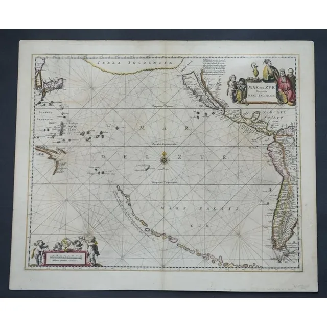
17th Century Jansson Map: Mar del zvr Hispanis Mare Pacificum
Rare antique 17th century map by Jansson, Jan, 1588-1664 - titled Mar del zvr Hispanis Mare Pacificum, approx 46 cm x 56 cm
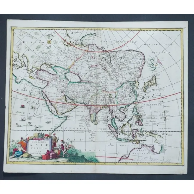
1690 Hand-Coloured Map of Asia by Joannem de Ram
Map, Asia, Joannem de ram Novatotius Asiae Tabula, published Amsterdam c.1690. Hand coloured engraving. 46 x 5 7 cm
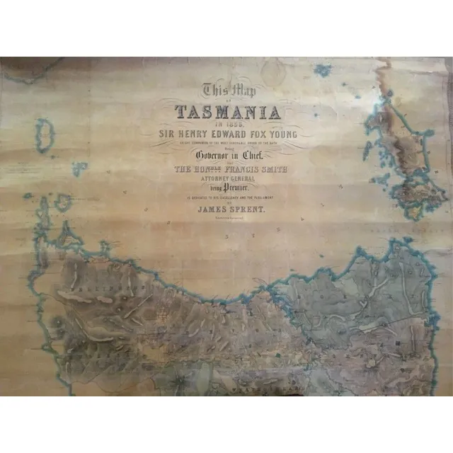
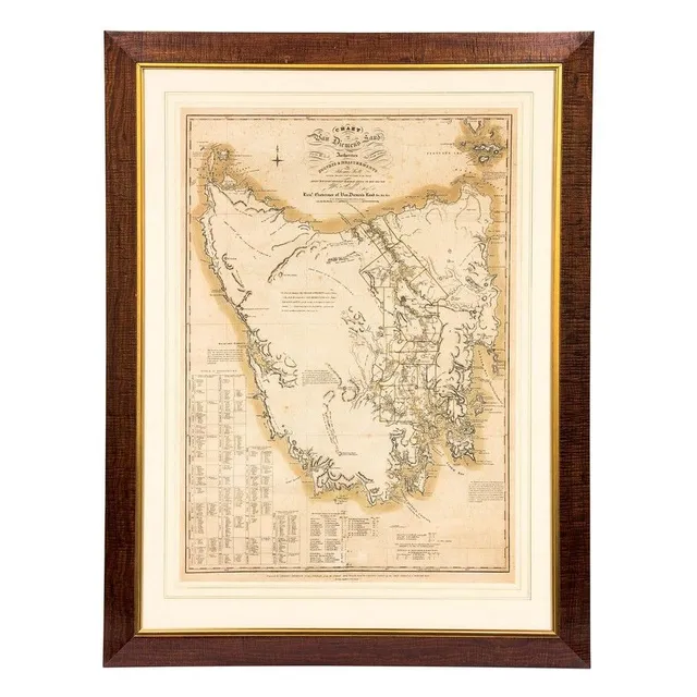
1859 Map of Tasmania by James Sprent
Sir Henry Edward Fox Young, 1859 map of Tasmania by James Sprent (large)
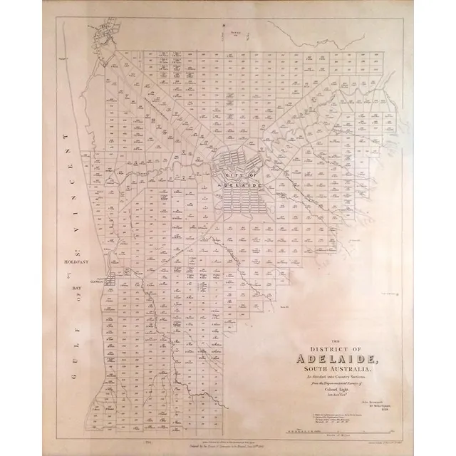
Adelaide District Map, 1840
Map of the District of Adelaide, South Australia, published by John Arrowsmith, 1840, lithograph, 65 x 55 cm
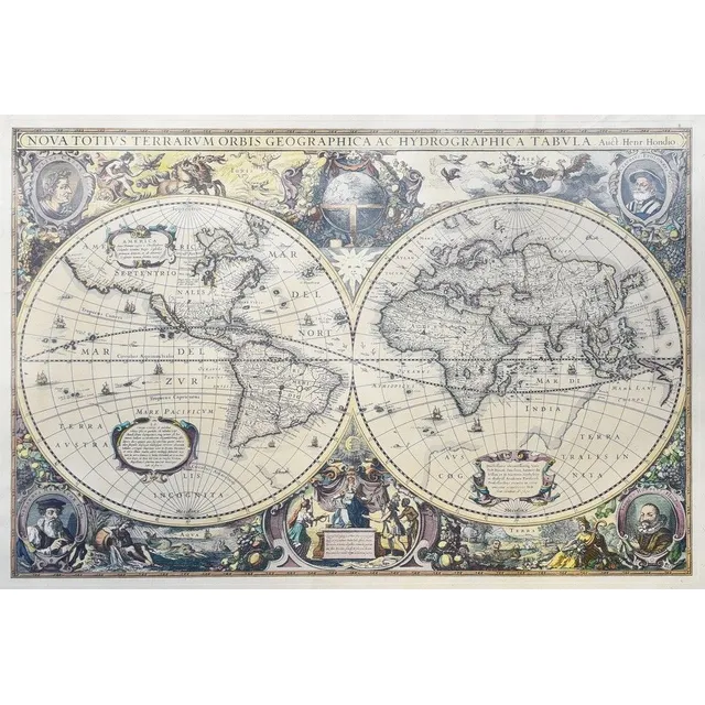
Map, Henricus Hondios 1597-1651, 'Nova Totius Terrarum Orbis Geographica AC Hydrographica Tabula' hand coloured engraving, first published Jan Jansson, Amsterdam 1630. 38.5 cm x 54.5 cm (plate)
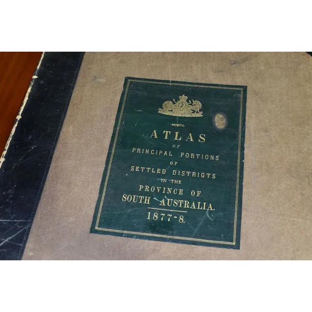
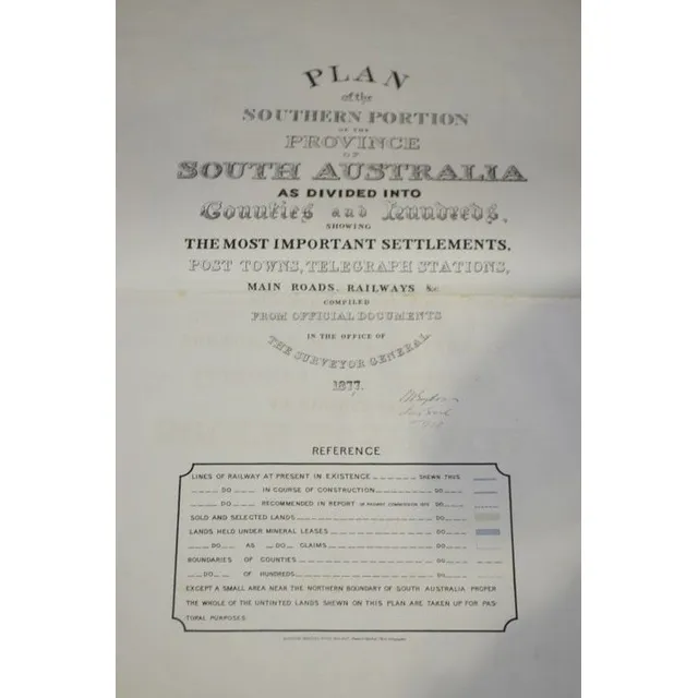
South Australia Atlas, G.W. Goyder, 1877-8
G.W. Goyder, plan of the Southern portion of the Province of South Australia, as divided into Counties and Hundreds, showing the most important Settlements, post Towns, Telegraph stations, main Roads, Railways &c. Compiled from official documents in the…
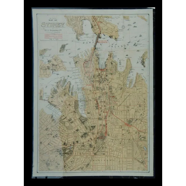
Sydney Map 1928: Wharves, Shipping, and Landmarks
Map of Sydney 2nd edition. H E C Robinson Ltd colour litho laid down on linen, enclosed in Mylar, (97 x 70 cm). North Shore bridge under construction (Sydney Harbour Bridge). All of the named wharves in Darling harbour, Walsh bay, Sydney cove, Johnstones…
South Australia County and Hundred Atlas 1877
Goyder: Atlas of South Australia as Divided into Counties and Hundreds 1877
![Bellin, Jacques Nicolas [1703-1772], Carte reduite des terres…](https://img.carters.com.au/640x640/a3675755c15f85ac2145abbb2d4b8adf.webp)
Reduced Chart of Southern Lands by Bellin, ca. 1753
Bellin, Jacques Nicolas [1703-1772], Carte reduite des terres Australes pour servir a l'histoire des voyages / par le Sr. Bellin, Ing. de la marine de la Societe Royale de Londres && ca. 1753, 22 x 29.5 cm (plate size). Original copperplate-engraved map…
India Orientalis Map, Ortetius, 1570
Map, India Orientalis. Published c.1570 Abraham Ortetius. Some restoration to centre fold. Hand coloured engraving. 35 x 5 0 cm
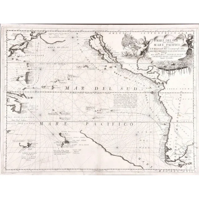
"Mare Del Sud" Map by Antonio Zatta (1776)
Italian 18th century map of the South Sea titled 'Mare Del Sud' by Antonio Zatta [Venice 1776]. 42 x 32 cm
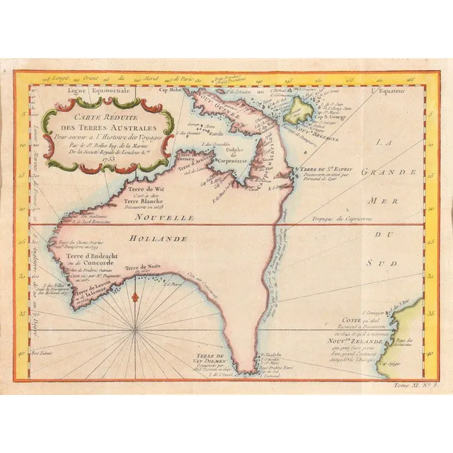
Dutch Discoveries in Early Australian Map
Carte Reduite De Terres Australes; Jacques Nicolas Bellin (1703-1772), Paris, circa 1753; the hand coloured early map of Australia with Dutch Discoveries. 30 x 22 cm
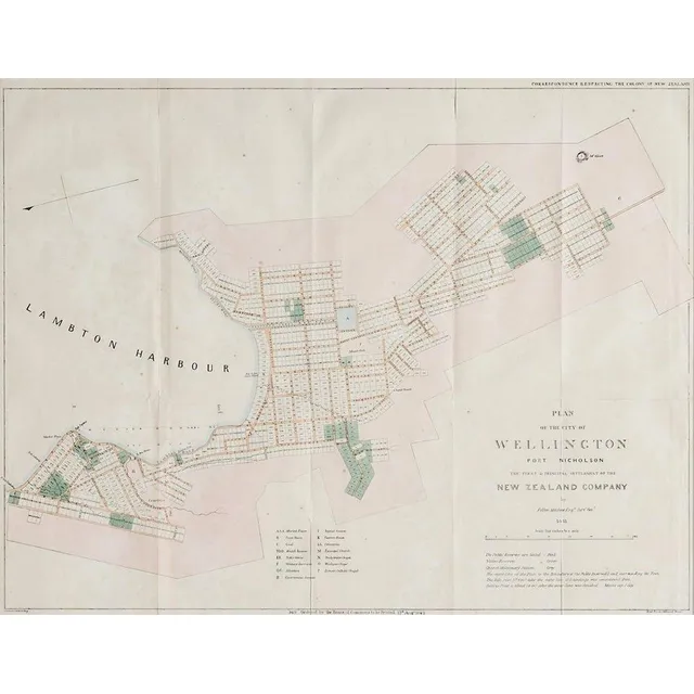
Wellington City Plan Map (1842)
A plan map for the City of Wellington, lithographic print, printed 1842 by Luke and James Hansard, lithographed by J.Arrowsmith. 48 x 61 cm
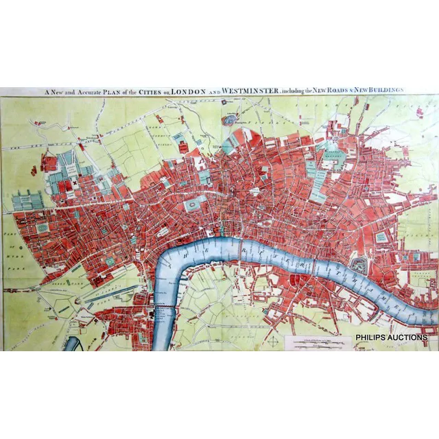
London and Westminster Map, 1754
A new and Accurate plan of the Cities of London and Westminster, including new Roads & new Buildings, circa 1754, the British library collection houses a 1765 version of this map, a fine, rare, hand coloured map marking the various stairways down to the…
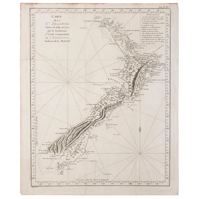
Cook's 1774 Map of New Zealand
New Zealand : James Cook: 'Carte de la N.le Zelande visitee en 1769 et 1770 par le Lieutenant J. Cook Commandant de l'Endeavour vaißeau de la Majeste', James Cook, Published Paris, 1774; engraved by Robert Benard. 49 x 38 cm. The original French edition…
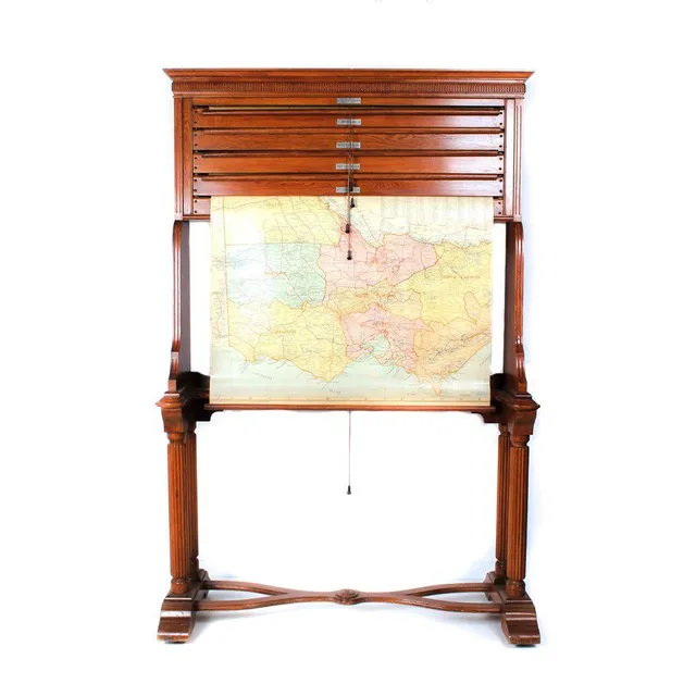
Craigie's Australian States Rotary Rolling Map Cabinet
Craigie's Australian states rotary rolling map box in blackwood cabinet, early 20th century, 97 cm high, 124 cm wide, 13 cm deep
Mar Del Zur Hispanis Mare Pacificum Map, 1650
Map, Mar Del Zur Hispanis Mare Pacificum. Jan Jansson mapmaker, published Amsterdam 1650. Hand coloured engraving. 44 x 5 5 cm
Map of the Pacific Ocean by V.M. Coronelli
Mare Del Sud, Detto Altrimenti Mare Pacifico; Vincenzo Maria Coronelli (1650-1718), Venice, circa 1691; an engraved and uncoloured map of the Pacific Ocean. 62 x 47 cm
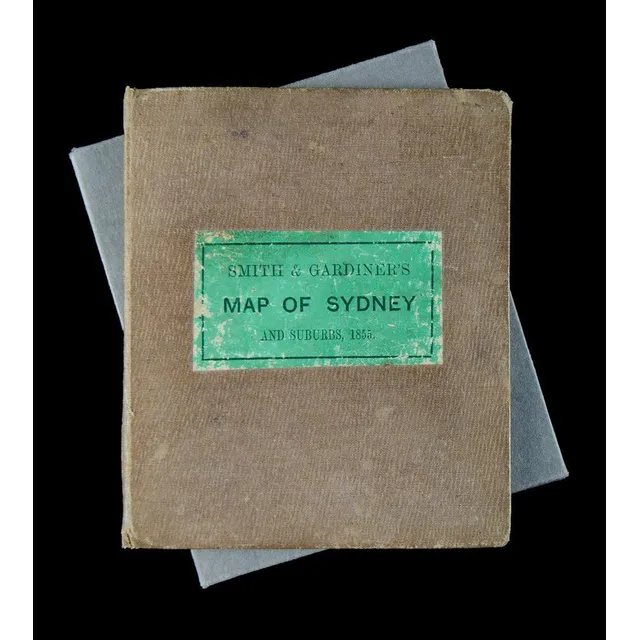
1855 Map of Sydney & Suburbs in Leather Binding
Smith & Gardiner's map of Sydney & Suburbs 1855. Leather bound cover (11.5 x 14 cm), inside folds out to a 32.5 x 38.5 cm map on material. Enclosed by a protective cardboard folder to fit.
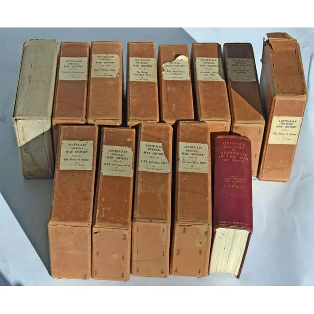
The Story of Anzac: C.E.W. Bean's 12 Volumes
Charles Edwin Woodrow bean (C.E.W. Bean) 1879 - 1968. The story of Anzac; 12 volumes with original covers 'From the outbreak of war to the end of the first phase of the Gallipoli campaign, May 4, 1915', with 111 maps and 56 illustrations Ninth edition,…
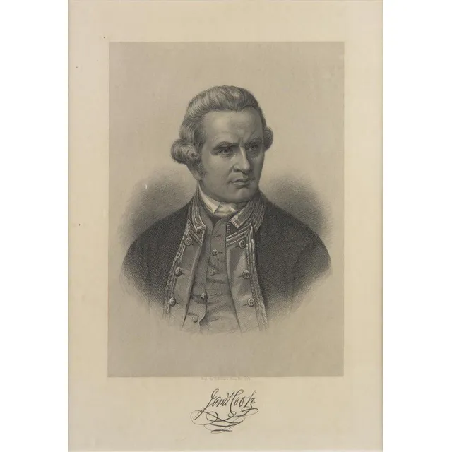
Captain Cook Chart and Portrait
Captain Cook: 'A New and Complete Chart of the World, Displaying the Tracks of Captn Cook, and other Modern Navigators' by Thomas Bowen [London, c1787], plus Portrait of Captain James Cook 'Engd. by H.B.Hall's Sons, New York' [c1880]. Both framed, various…
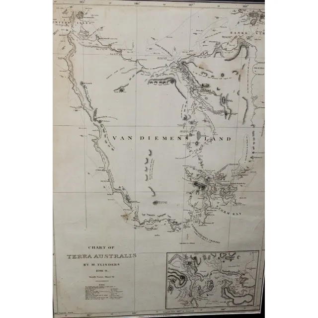
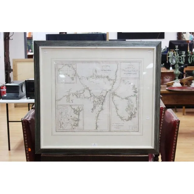
Chart of Terra Australis by M. Flinders 1798
Chart of Terra Australis by M. Flinders 1798, 99 published 1814, G&W Nicol 66 cm x 46 cm
Nouvelle Hollande Map, 1753
Map, Nouvelle Hollande, 1753. Cartographer Bellin, as published in Prevost Histoire Generale des Voyages, Paris, 1753, height and coloured copper engraving, 21 x 28 cm
Rare Map of New South Wales and British Settlements
Rare Chart / Map of New South Wales (Van Diemen's Land) & Survey in the Interior of New South Wales, also showing the British Settlements at Port Jackson, J, Aspin, Hewitt Buckingham Place, approx 52 cm x 62 cm (Excellent condition, framed and glazed) See…
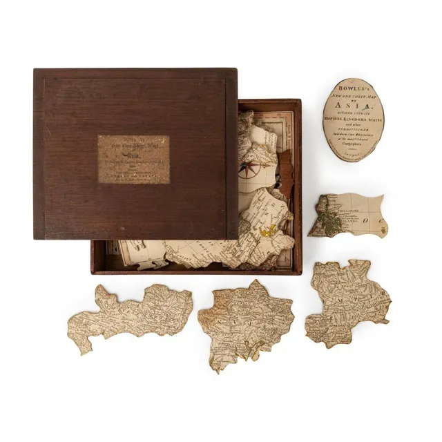
Bowles's One-Sheet Map of Asia Puzzle, c. 1801
Bowles's new One-Sheet map of Asia, divided into its Empires, Kingdoms, States, &c., [Bowles and carver, St. Paul's church Yard], circa 1801, Dissected map, 54 pieces with three blank replacement pieces (the lost pieces in the regions of Java, Sumatra and…
Seutter's 17th Century World Map
Matthias Seutter 17th century map, entitles 'Diversi Globi Terr-Aquei Statione Variante et Visu Intercedente, per Ambos Polos et Particul. Sphaerae Zenith in Planum Delineati Orthographici Prospectus, Quibus Additae pro Mutatione Horizontis Differentes…
Hand-Coloured Map of England, 1681
Ionhannah Van Keulen, Engeland, hand coloured map, circa. 1681, 50 cm high, 55 cm wide
Dutch Discoveries in New Holland and Indian Ocean (1684)
Terres Australes; Pierre du Val (1619-1683), Paris, 1684; a hand coloured map of the Dutch Discoveries in the New Holland and the Indian Ocean. Third issue, the first being 1677. 59.5 x 42 cm
Hand-Coloured Lunar Map by Johann Gabriel Doppelmair
Tabula Selenographica, Johann Gabriel Doppelmair (1671-1750), Nuremberg, circa 1742, hand coloured engraved double-hemisphere of the lunar surface, vertical seam to centre, the map, 47.5 x 59 cm. Provenance: Purchased from Baynton- Williams, London in the…
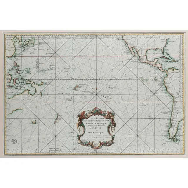
Pacific Ocean Discoveries 1700s
Bellin, Jacques Nicolas (1703-1772). 'Carte Reduite Des Mers Comprises Entre L'Asie et L'Amerique Apelees par les Navigateurs Mer Du Sud ouMer Pacifique...', [Paris: Depot de la Marine, 1776.], attractively hand-coloured, 55 x 82 cm (image), 83 x 112 cm…
Vintage Australian Map Stand
Map stand, early 20th century classic style yellow oak (maple?), stand containing five state maps on Rollers showing pastoral Stations of Australia etc, by H E C Robinson Ltd George Street Sydney
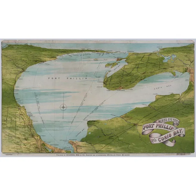
Bird's Eye View of Port Phillip & Corio Bay (1872)
(Victoria) 'Bird's Eye View Of Port Phillip And Corio Bay' 1872, Colour lithograph, title in image lower right, publisher's line in lower margin, 41 x 68 cm. Old folds, scratches and stains, repaired tears and slight paper loss. Linen-backed. 'Published…
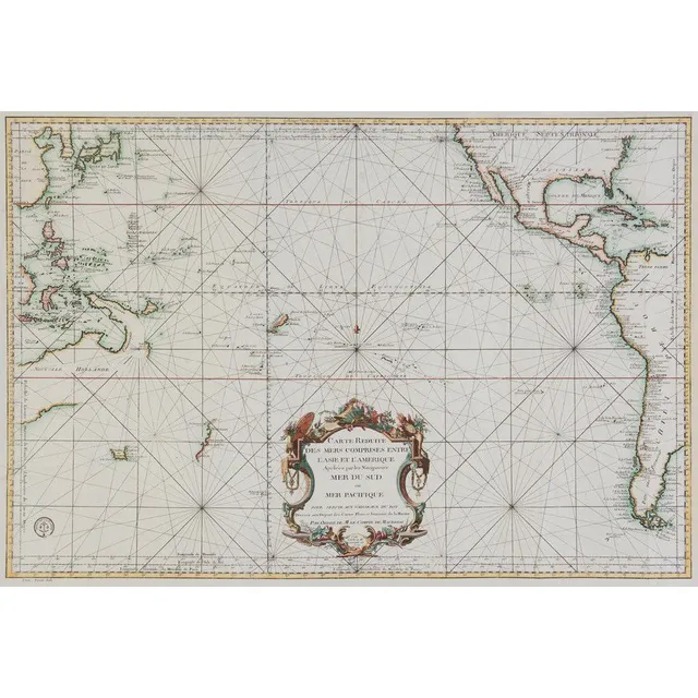
South Pacific and Surrounding Coasts, 1776
Bellin, Jacques Nicolas, 1776, Carte Reduite des Mers Comprises Entre l'Asie et l'Amerique Apelees par les Navigateurs Mer du Sud ou Mer Pacifique.., Paris, 1776, 63 x 89 cm. The chart focuses on the South Pacific, extending to China, Korea & Japan in the…
French Map of South West Australia, 1792-1793
Map original early French map of south West Australia depicts, Rottnest, swan river, Pt. Leeuwin etc.. A fairly rare copper plate engraving. Shows the voyages of the French vessels, Resecherche and Esperance in 1792 to 1793. Published as plate number 11…
The First Detailed Mapping of The Adelaide Region, Carte Generale de la Terre Napoleon, [Baudin Expedition map] Louis de Freycinet, [Paris: grave par Tardieu, 1808.], attractively hand coloured, 54 x 78 cm (sight); framed 80 x 104 cm. At the time of the…
Mortier's Pacific Ocean Map, 1700
Mortier Pacific Ocean map. 'Mer de Sud ou Pacifique' from suite du Neptune Francois pub. Amsterdam 1,700. Short edge tears, foxing. Hand coloured copper engraving, 60 x 75 cm (plate)
New World Chart with British and La Perouse's Tracks
Laurie & Whittle, (London, 1800), A New Chart of the World on Wright's or Mercator's Projection in which are Exhibited all the parts hitherto Explored or discovered with the Tracks of the British Circumnavigators Byron, Wallis, Carteret and Cook, &c. and…
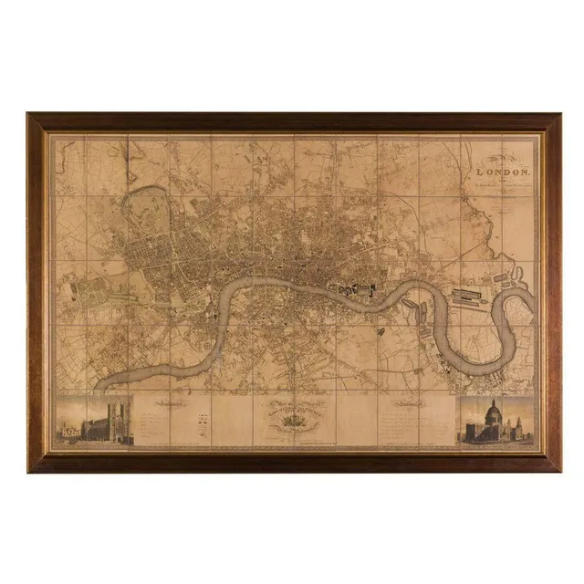
Greenwood's 1827 Map of London
A large map of London after the original by C & J Greenwood, 1827, 124 x 192 cm
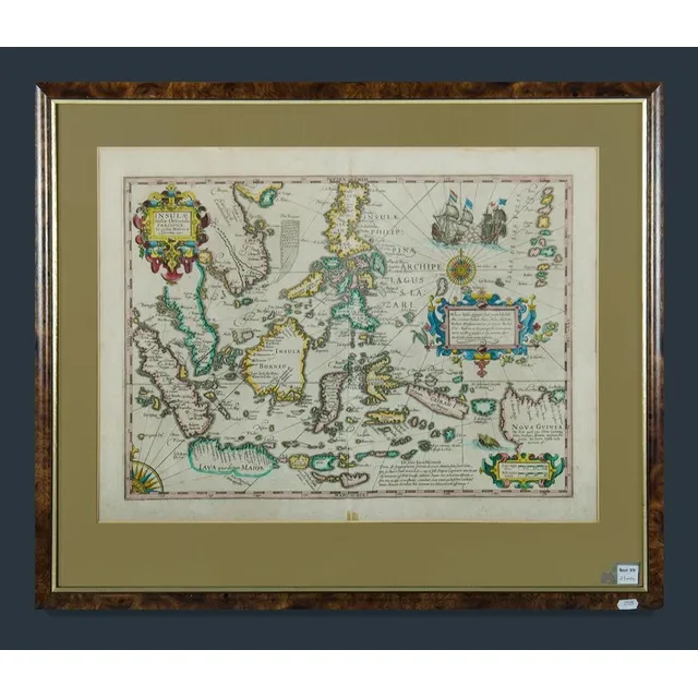
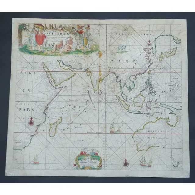
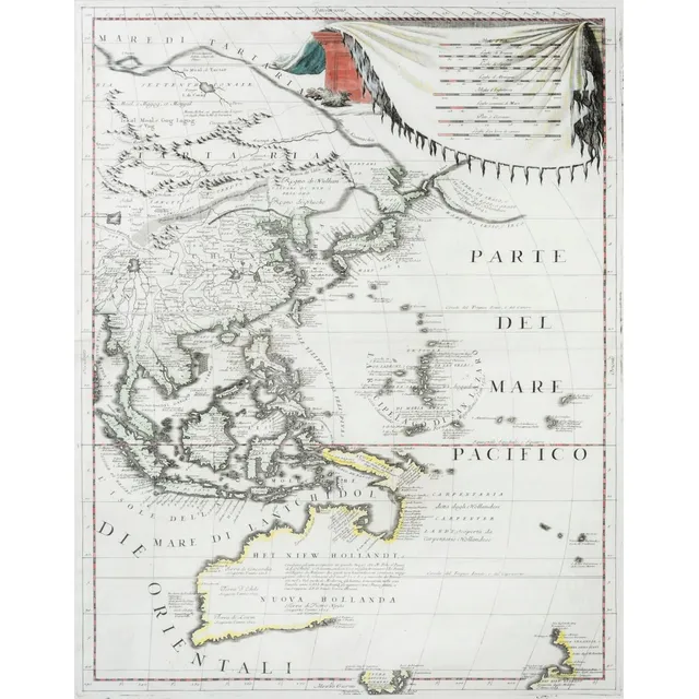
East Indies Map with New Guinea
Framed decorative colour map of the East Indies showing a portion of New Guinea. Insulae Indicae Orientalis Precipual. Image (40 x 53 cm) frame (57 x 68 cm)
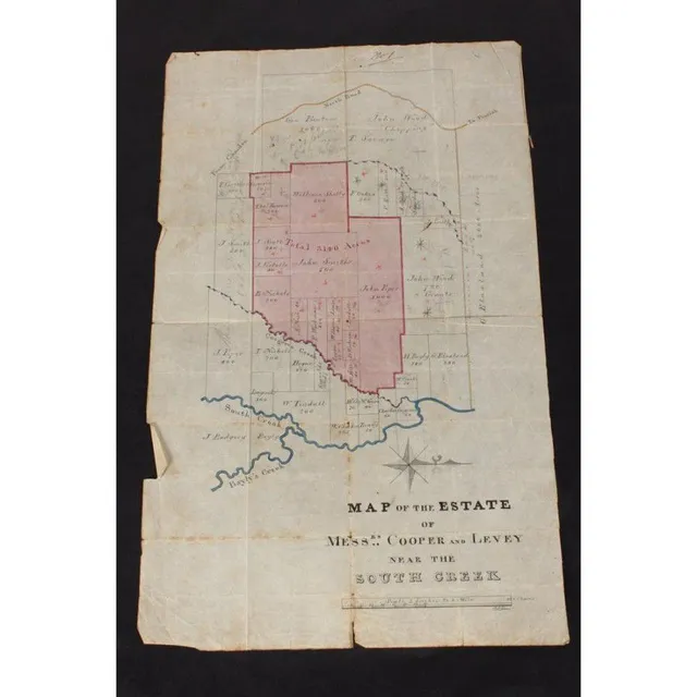
Estate of Copper and Levey Hand-Drawn Map
Australian Colonial hand drawn map of the Estate of copper and Levey, near south creek (Badgery Creek), showing the current landowners such as John Piper and Blaxland and the areas that Cooper and Levey were acquiring, signed P.L Bemi, 42 cm x 26 cm

Calvert Expedition, Australia 1896
Hill. J.G., compiler. The Calvert Scientific Exploring Expedition, Australia, 1896. London, 1905. Small quarto, pp. viii, 44, with frontispiece map and large folding map, original cloth., Scarce acount of this disastrous Western Australian expedition led…
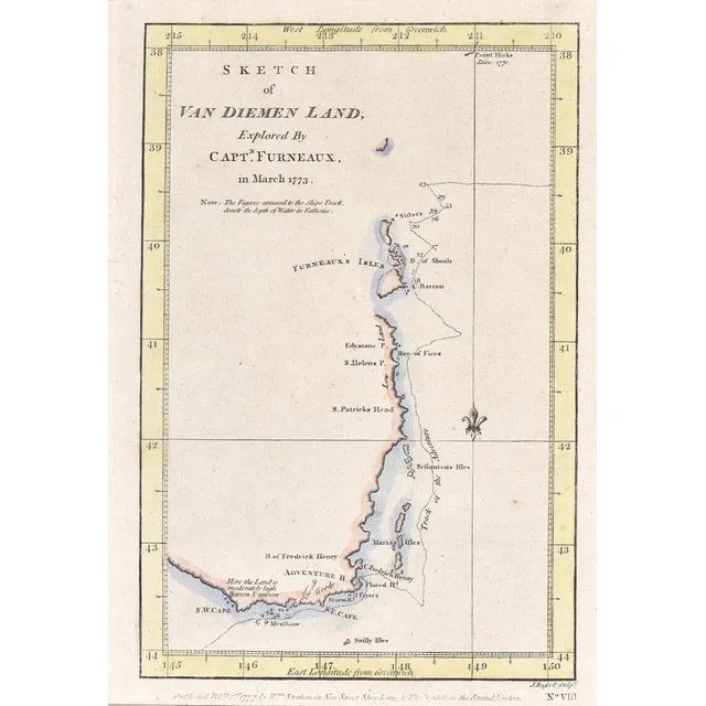
First British Map of Tasmania, 1777
Sketch of van Diemen land; Strahan & Cadell, London, 1777; Explored by Captain Furneaux in March 1773, hand coloured. Being the first British chart of Tasmania. 23 cm x 16 cm
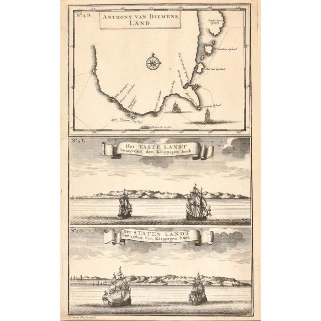
Early Map of Tasmania and Abel Tasman's Voyage
Anthony van Diemens Land; Francois Valentijn, Amsterdam, circa 1726; an early map of Tasmania showing the track of Abel Tasman's epic first voyage of 1642-1643, which resulted in the discovery of Tasmania and New Zealand. 19 cm x 30 cm
New Map of East India and Adjacent Islands, 1670
Map, Indiae Orientalis nec Non Insularum Adiacentium Nova Descriptio. Map maker Nicholaus Visscher, pub. Amsterdam, 1670. Hand coloured engraving. 48 x 5 8 cm
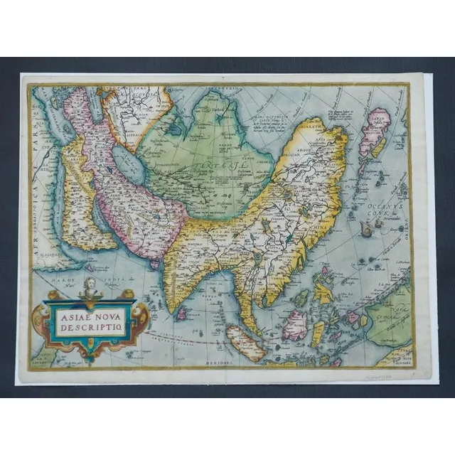
Ortelius' Map of Asia, 1574
Map, Asiae Nova Descriptio. Map of Asia by Abraham Ortelius, pub. Amsterdam c.1574. Hand coloured engraving. 37 x 4 9 cm
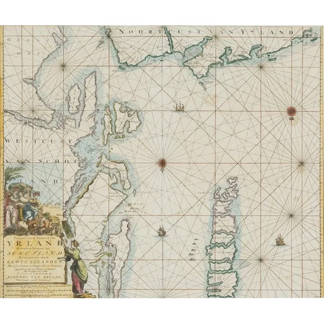
Hand-Coloured Map of Scotland and Ireland (1681)
Jjoannes Van Keulen, Yrland, Schotland, hand coloured map, circa. 1681, 50 cm high, 58 cm wide
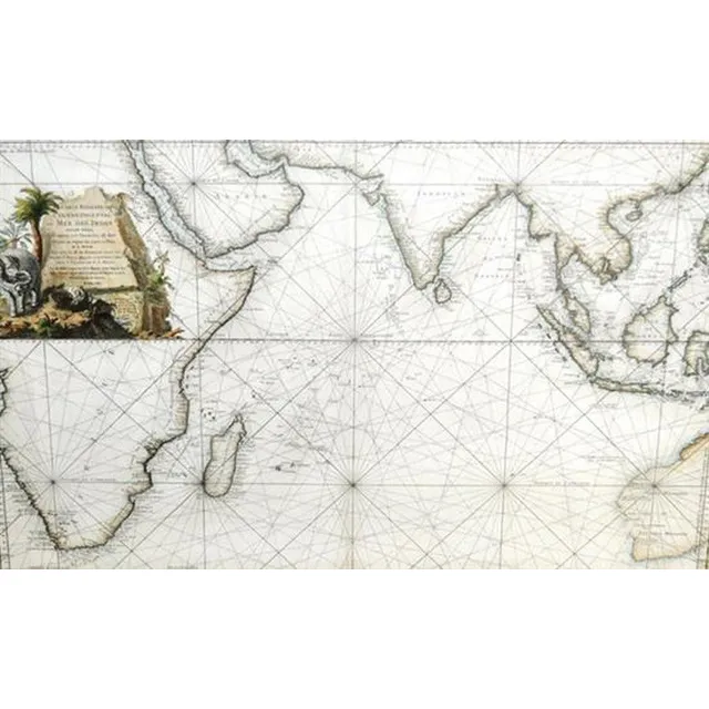
Eastern Ocean Map
After Jacques Nicolas Bellin, (1703 - 1772) France, Map - 'Carte Reduite de L'Ocean Oriental ou mer des Indes, Hand coloured engraving, 57 x 88 cm
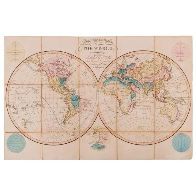
Wallis's new game, Exhibiting a voyage round the world. Wallis, Edward. [Published by published by E. Wallis, 42 Skinner Street and 12 high Street, Islington] c.1823. Engraved game map with hand colour, dissected and mounted on linen, folding into o
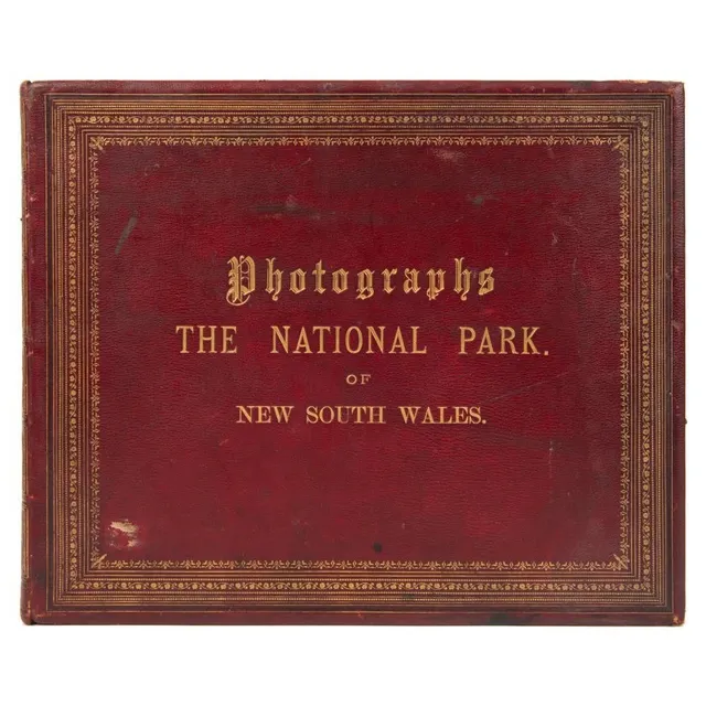
Leather-bound, gilt-titled and decorated album: 'Photographs - the National park of New South Wales.' containing 32 images with a printed map and introductory page from the Government Printing office dated March 1888; followed by an index to the ima