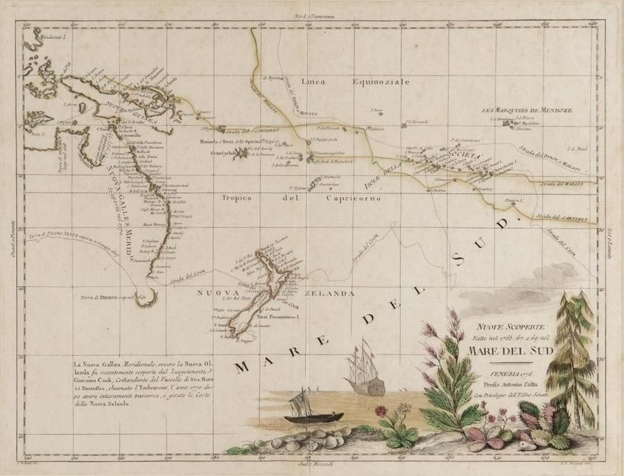
"Mare Del Sud" Map by Antonio Zatta (1776)
You must be a subscriber, and be logged in to view price and dealer details.
Subscribe Now to view actual auction price for this item
When you subscribe, you have the option of setting the currency in which to display prices to $Au, $US, $NZ or Stg.
This item has been included into following indexes:
- maps - general 445
Visually similar items
Nuove Scoperte, Fatte nel 1765, 67, e 69 nel, Mare Del Sud' by Antonio Zatta [Venice, 1776], window mounted, overall 57 x 49 cm. Tooley 1431.

Benard, Robert (Paris, 1774), Carte d'une partie de la Mer du Sud Contenant les Decouvertes de Vaisseaux de sa Majeste: Le Dauphin, Commodore Byron, la Tamar, Capitne Mouats, 1765. Le Dauphin, Capitne Wallis, Le Swallow, Capitne Cartaret, 1767. et l'Endeav

(World map) Heinrich Robert / F. A. Schraembl, 1789, Generalkarte soemmtlicher Entdeckungen auf den drei Grossen Weltreisen des Kapit Jacob Cook. Two sheets, each 49 x 60 cm to the printed margins. Large world map showing the routes of three voyages made b

Map, 'Royaume de Hongrie et Pays Adjacents,' par M.Bonne, Andre Scul. Engraving. 25 x 36 cm