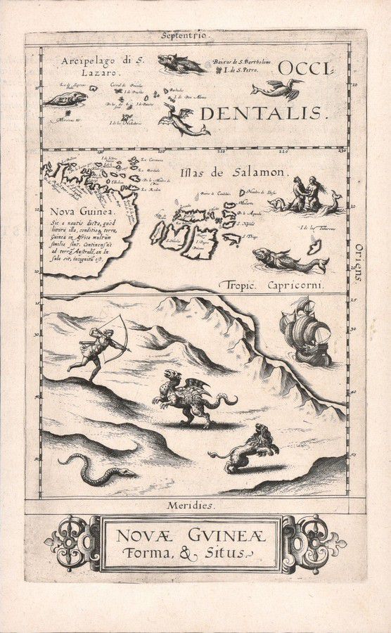
First Printed Map of Australia: Nova Guinea Forma & Situs
You must be a subscriber, and be logged in to view price and dealer details.
Subscribe Now to view actual auction price for this item
When you subscribe, you have the option of setting the currency in which to display prices to $Au, $US, $NZ or Stg.
- Griffin / Griffon / Gryphon - A griffin, also known as a griffon or gryphon, is a mythical creature with the body of a lion and the head of an eagle. It is typically depicted as a powerful and majestic beast, with the body and legs of a lion and the head, wings, and talons of an eagle. The griffin is widely recognized as a symbol of strength, courage, and guardianship, and has been used in a variety of cultures throughout history.
In ancient mythology, the griffin was often associated with the gods and was considered a symbol of divine power. In ancient Greece, for example, the griffin was associated with the sun god Helios, while in ancient Egypt, it was associated with the goddess Hathor. In medieval European heraldry, the griffin was used as a symbol of strength, valour, and protection, and was often featured on the coats of arms of noble families. - Gryphon - A gryphon is a mythical beast with the head of an eagle and the body of a lion.
This fictional character was devised by Lewis Carroll in "Alice's Adventures in Wonderland", written in 1865.
This item has been included into following indexes:
- maps - general 445
Visually similar items

Australia: Collection of maps in folder, noted 'Chart of the Track of the Dolphin, Tamar, Swallow & Endeavour through the South Seas...' by Bowen [London, 1773], 'Karte von Australien' by Johannes Walch [Augsburg, c1810], 'Oceanique Centrale' by Pierre Lap

Map, 'Royaume de Hongrie et Pays Adjacents,' par M.Bonne, Andre Scul. Engraving. 25 x 36 cm

A George III linen cross-stitch needlework sampler, English, 19th century, worked by Ann Hill at M. Chapmans school and dated 1804. 44 cm high, 30 cm wide
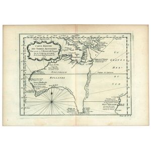
Carte Reduite Des Terres Australes, Pour servir a l'Histoire des Voyages' by Jacques Bellin, [Paris, 1753], lovely map showing hypothetical east coast of Australia, 36 x 25 cm.