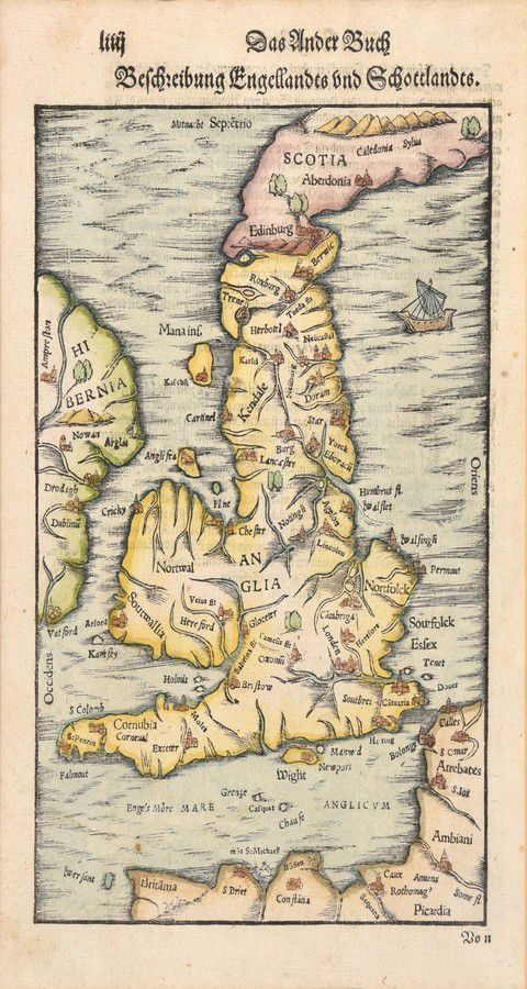
16th Century Hand-Coloured Map of England and Scotland
You must be a subscriber, and be logged in to view price and dealer details.
Subscribe Now to view actual auction price for this item
When you subscribe, you have the option of setting the currency in which to display prices to $Au, $US, $NZ or Stg.
- Circa - A Latin term meaning 'about', often used in the antique trade to give an approximate date for the piece, usually considered to be five years on either side of the circa year. Thus, circa 1900 means the piece was made about 1900, probably between 1895 and 1905. The expression is sometimes abbreviated to c.1900.
This item has been included into following indexes:
- maps - general 445
Visually similar items

MALLET MAPS, 'Nouvelle Guinee et Carpentarie'&'Des Terres Australes', by Allain Manesson-Mallet [Paris, 1683], both window mounted, framed &glazed, each about 28 x 34 cm. Early maps showing Australia &NZ
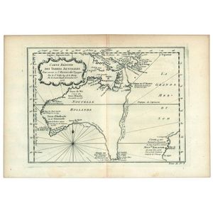
Carte Reduite Des Terres Australes, Pour servir a l'Histoire des Voyages' by Jacques Bellin, [Paris, 1753], lovely map showing hypothetical east coast of Australia, 36 x 25 cm.

Map, NSW, New Zealand, New Hebrides & the Islands Adjacent. Robert Wilkinson, pub. London 1808. Inset map of port Jackson & Environs. Coloured engraving

A George III linen cross-stitch needlework sampler, English, 19th century, worked by Ann Hill at M. Chapmans school and dated 1804. 44 cm high, 30 cm wide