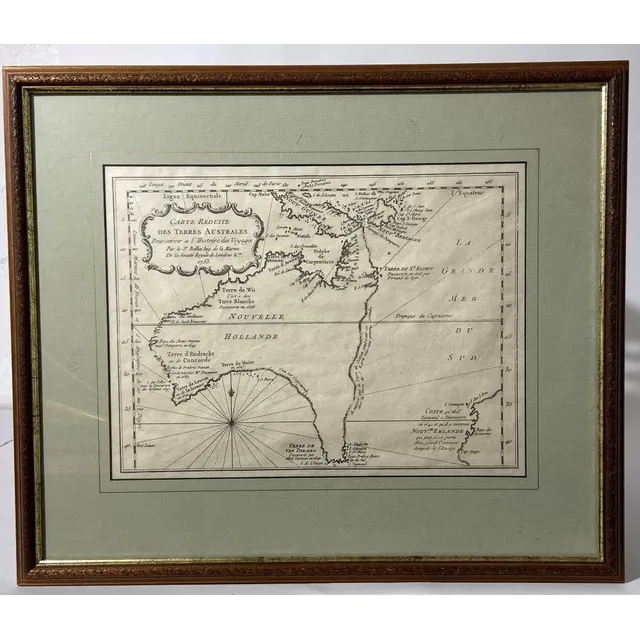
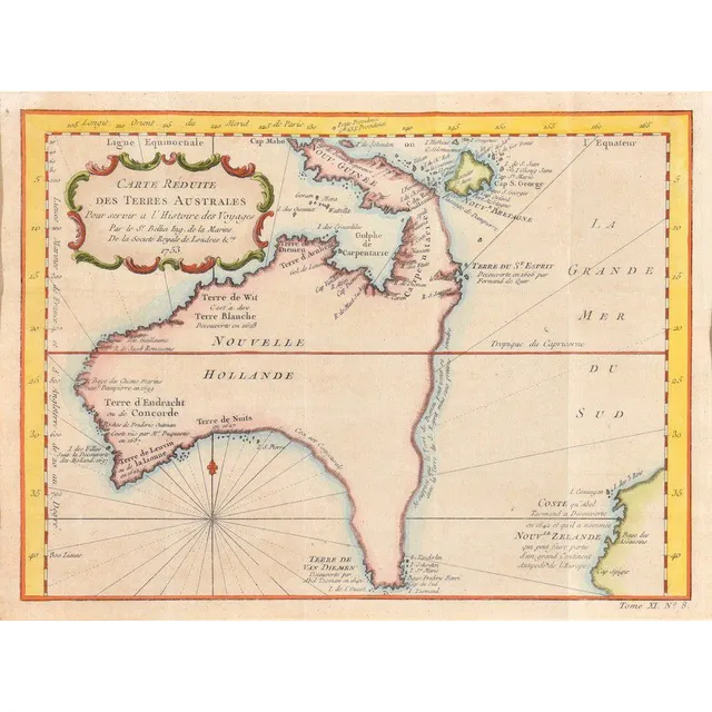
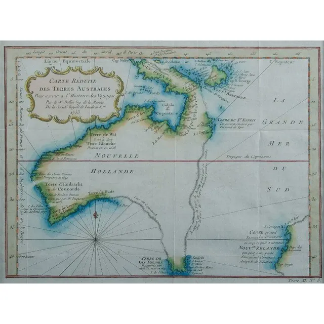
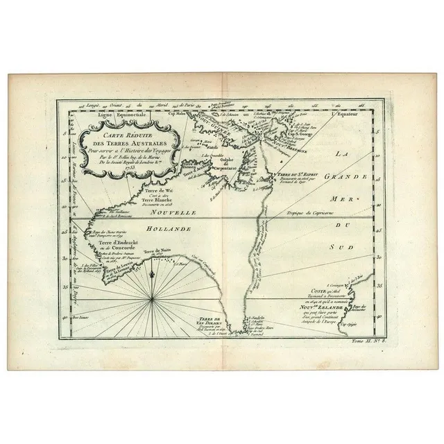
Bellin, J.N. Carte Reduite Des Terres Australes, facsimile of 1753 chart, mounted & framed, frame 38 x 45 cm
Pacific Ocean Discoveries 1700s
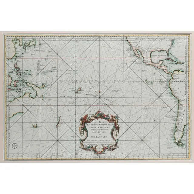
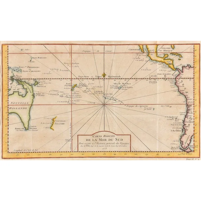
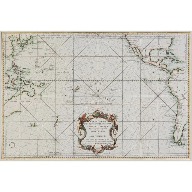
Bellin, Jacques Nicolas (1703-1772). 'Carte Reduite Des Mers Comprises Entre L'Asie et L'Amerique Apelees par les Navigateurs Mer Du Sud ouMer Pacifique...', [Paris: Depot de la Marine, 1776.], attractively hand-coloured, 55 x 82 cm (image), 83 x 112 cm…
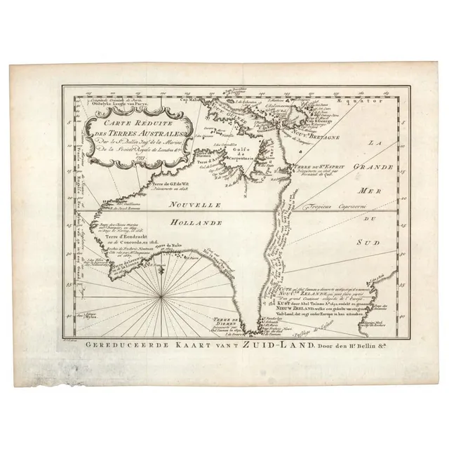
1758 Dutch Edition Map of Hypothetical East Coast Australia
Jacques Bellin: 'Carte Reduite Des Terres Australes, Par le Sr Bellin....', (Paris, 1753), lovely map showing hypothetical East coast of Australia, being the Dutch edition of 1758, 36 x 25 cm. This Dutch edition, published in 1758, is scarcer than its…
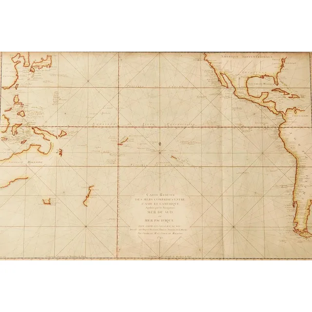
Cartes et plans de l'Amerique, c.1742
Bellin, Jacques Nicolas, 1703-1772 - Cartes et plans de l'Amerique, c.1742. Facsimile from original plate. Framed and mounted. 56 cm x 86 cm
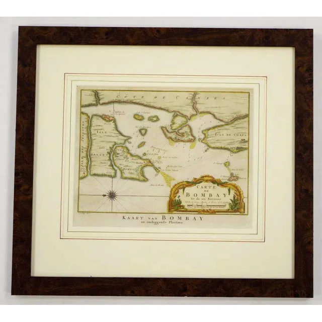
Bombay Map, 1755
Mid 18th century coloured copper plate map 'Carte de Bombay Et de ses Environs', circa 1755, by Jakob van der Schley & Jacques Nicolas Bellin, 21 cm x 26 cm and 41.5 cm x 46 cm frame
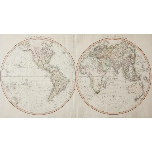
Bellin's Hemispheres Map, 1742
Jacques-Nicolas Bellin - maps of the Hemispheres, C.1742, hand coloured print, map shows the Eastern Hemispere and the Western hemisphere and was made under the direction of the secretary of state to the King of France., 500 x 89.5 cm
South Pacific Ocean Map (1753)
Jacques-Nicolas Bellin - map of South Pacific Ocean, C.1753, engraved on paper, 230 x 38 cm
![Bellin, Jacques Nicolas [1703-1772], Carte reduite des terres…](https://img.carters.com.au/640x640/a3675755c15f85ac2145abbb2d4b8adf.webp)
Reduced Chart of Southern Lands by Bellin, ca. 1753
Bellin, Jacques Nicolas [1703-1772], Carte reduite des terres Australes pour servir a l'histoire des voyages / par le Sr. Bellin, Ing. de la marine de la Societe Royale de Londres && ca. 1753, 22 x 29.5 cm (plate size). Original copperplate-engraved map…
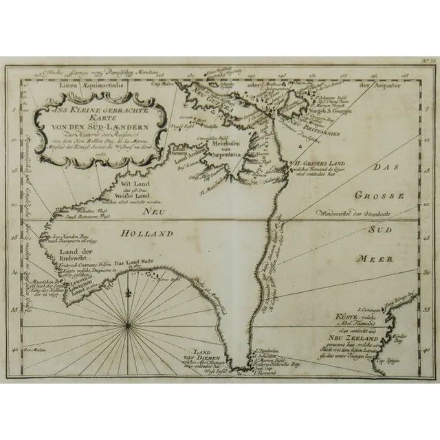
Australia Map, 1753
Map, Australia, by Jacques Nicholas Bellin, 'Ins Kleine Gebrachte Karte von den Sud-Landern', 1753. Copper engraving, 20 x 27.5 cm.
Dutch Discoveries in Early Australian Map
Carte Reduite De Terres Australes; Jacques Nicolas Bellin (1703-1772), Paris, circa 1753; the hand coloured early map of Australia with Dutch Discoveries. 30 x 22 cm
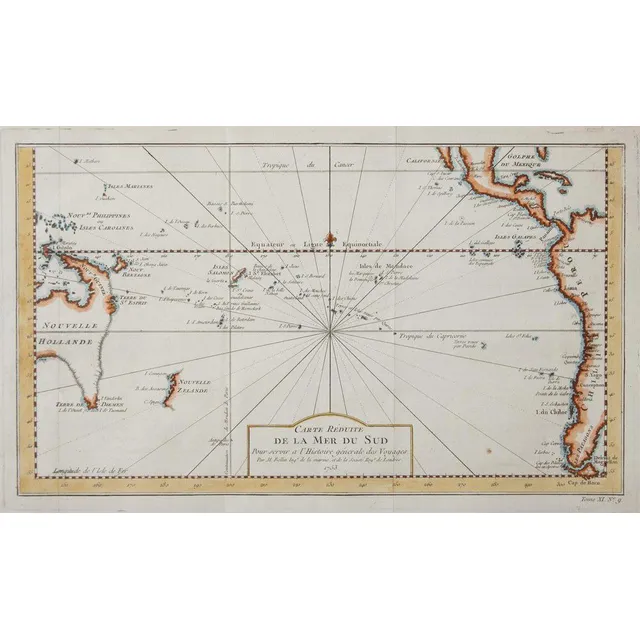
Reduced Map of the South Pacific
Carte Reduite De La Mer Del Sud; Jacques Nicolas Bellin (1703-1772), Paris, circa 1753; the hand coloured early map of Australia and New Zealand. 36 cm x 21 cm
Nouvelle Hollande Map, 1753
Map, Nouvelle Hollande, 1753. Cartographer Bellin, as published in Prevost Histoire Generale des Voyages, Paris, 1753, height and coloured copper engraving, 21 x 28 cm
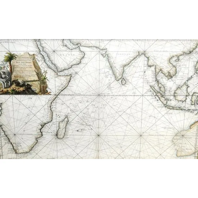
Eastern Ocean Map
After Jacques Nicolas Bellin, (1703 - 1772) France, Map - 'Carte Reduite de L'Ocean Oriental ou mer des Indes, Hand coloured engraving, 57 x 88 cm
South Pacific and Surrounding Coasts, 1776
Bellin, Jacques Nicolas, 1776, Carte Reduite des Mers Comprises Entre l'Asie et l'Amerique Apelees par les Navigateurs Mer du Sud ou Mer Pacifique.., Paris, 1776, 63 x 89 cm. The chart focuses on the South Pacific, extending to China, Korea & Japan in the…
Hypothetical East Coast of Australia, 1753
Carte Reduite Des Terres Australes, Pour servir a l'Histoire des Voyages' by Jacques Bellin, [Paris, 1753], lovely map showing hypothetical east coast of Australia, 36 x 25 cm.
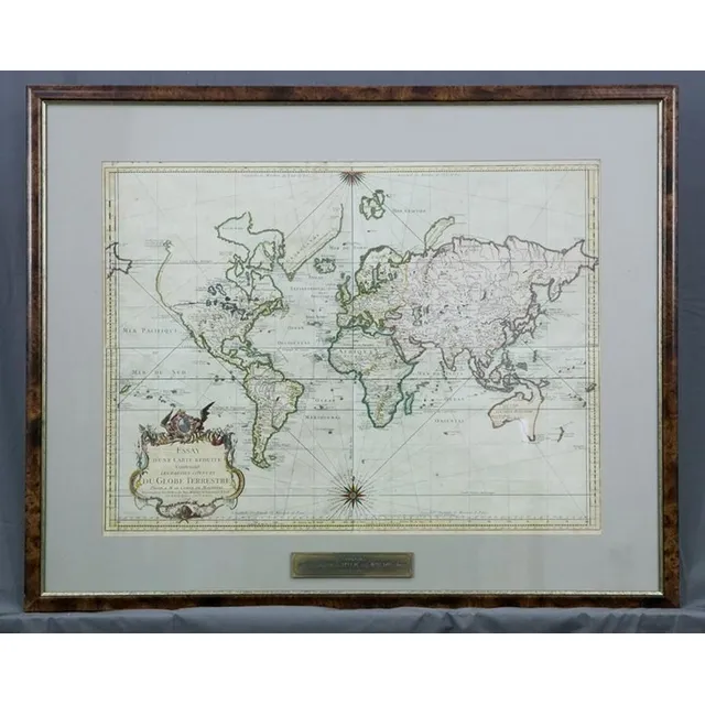
World Map 1748 by Bellin
Map, the world, 1748. 'Essay d' Une Carte Reduite Contenant les Partes Connuees du globe Terrestre,' by Jacques-Nicolas Bellin. Coloured copper engraving. 48 x 64 cm
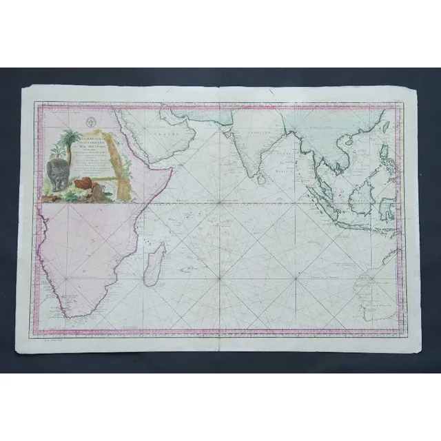
Eastern Ocean Map, Bellin, Paris 1757
Map, Carte Reduite de L'Ocean Oriental ou Mer des Indes. Mapmaker J N Bellin, pub. Paris, 1757. Hand coloured engraving. 56 x 8 8 cm
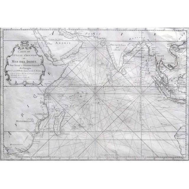
Carte de L'Ocean Oriental (Map of Eastern Ocean)
MAP - Bellin, Jacques Nicolas. Carte de L'Ocean Oriental ou Mer Des Indes, Paris, Didot, 1750. Engraved map, covers the entire Indian Ocean. Eastern coast of Africa and Madagascar depicted along with southern Arabia and India. Indonesian Islands and…