1829 Map of Perth Waters and Swan River

You must be a subscriber, and be logged in to view price and dealer details.
Subscribe Now to view actual auction price for this item
When you subscribe, you have the option of setting the currency in which to display prices to $Au, $US, $NZ or Stg.
This item has been included into following indexes:
- maps - general 445
Visually similar items

1792 Chart of the Coast between Botany Bay & broken Bay. As surveyed by Capt. John hunter. Pub. By John Stockdale, London 1792. Engraving. 43 x 75 cm
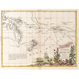
Nuove Scoperte, Fatte nel 1765, 67, e 69 nel, Mare Del Sud' by Antonio Zatta [Venice, 1776], window mounted, overall 57 x 49 cm. Tooley 1431.

Pringle, James: Found guilty of stealing a shovel at Northumberland Quarter Sessions, and transported for 7 years aboard the 'Maria Somes' (departed 22 April 1844, arrived at Vdl 30 July 1844): printed vellum document filled out in mss in various hands, be

Slowman, John: Found Guilty of burgulary at the Central Criminal Court, London and transported for 14 years aboard the 'Anson' (departed 23rd Sept.1843, arrived at Vdl 4th Feb.1844): printed vellum document filled out in mss in various hands, being a compl