1862 Map of South Australia

You must be a subscriber, and be logged in to view price and dealer details.
Subscribe Now to view actual auction price for this item
When you subscribe, you have the option of setting the currency in which to display prices to $Au, $US, $NZ or Stg.
This item has been included into following indexes:
- maps - general 445
Visually similar items

Mornington County & Cranbourne Maps: c1875-1904 maps, noted 'The Township of Mornington, Snapper Point', 'Cranbourne', 'Balnarring', 'Pakenham', 'Woolamai', 'Nar-Nar-Goon', 'Poowong & Jeetho', 'Korumburra'. Various sizes. Poor/G condition.,
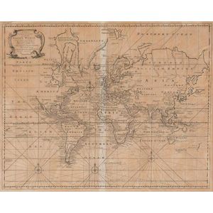
A New & Correct Chart of all the Known World by Emanuel Bowen [London 1744]. 46 x 38 cm

1792 Chart of the Coast between Botany Bay & broken Bay. As surveyed by Capt. John hunter. Pub. By John Stockdale, London 1792. Engraving. 43 x 75 cm

'Wisden Cricketers' Almanack for 1879', original paper wrappers. Fair/Good condition.