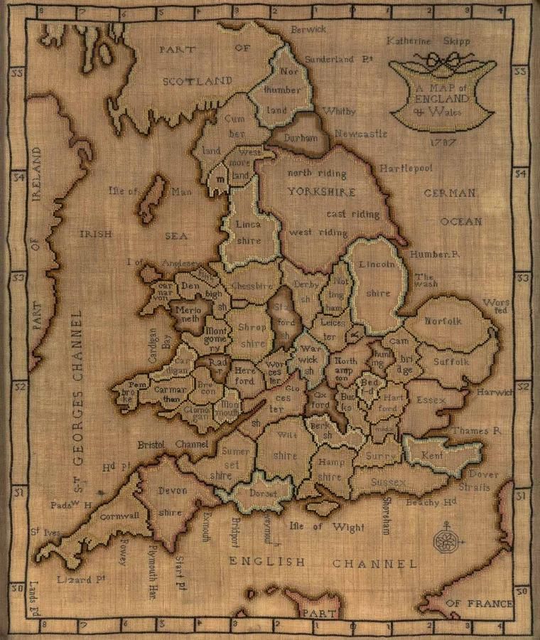
18th Century English Needlework Map Sampler
You must be a subscriber, and be logged in to view price and dealer details.
Subscribe Now to view actual auction price for this item
When you subscribe, you have the option of setting the currency in which to display prices to $Au, $US, $NZ or Stg.
- Cross Stitch - Cross stitch is a form of embroidery that involves creating a pattern or design by sewing X-shaped stitches onto fabric. The stitches are typically made using a needle and thread, and are made in a grid pattern, with each X-shaped stitch crossing over one or more fabric threads. The stitches are usually made with a single thread of embroidery floss, and the thread is passed over one fabric thread and under the next, creating the X-shape.
Cross stitch is one of the oldest forms of embroidery and has been used for centuries to create decorative patterns and designs on clothing, linens, and other fabrics. The technique is simple and easy to learn, making it a popular hobby for people of all ages and skill levels. Cross stitch patterns can range from simple geometric designs to more complex, detailed images such as landscapes, portraits, and characters.
Cross stitch is also used in the production of samplers, a traditional form of embroidery that features a variety of different stitches and patterns produced as a way to practice and demonstrate needlework skills.
This item has been included into following indexes:
- samplers 210
Visually similar items

A rare 1780 'Map of England & Wales by Martha Wiggins' sampler, worked in coloured threads for the various counties, Cheshire, Derby, York, etc., their names in black thread, various sea's and channel's further detailed, an outer border of latitude and lon

Map, 'Royaume de Hongrie et Pays Adjacents,' par M.Bonne, Andre Scul. Engraving. 25 x 36 cm

Thomes Bowen (?-1790) A new and Accurate map of Asia, drawn from the most modern Maps and Charts, 1799 Handcoloured & engraved, for Middletons complete System of Geography 32.5 x 42.5 cm

A colonial surveyor's map, 'Plan of the town of Launceston, Van Diemen's Land, from the actual survey by H. W. H. Smythe, 1855', 64 cm high, 78 cm wide