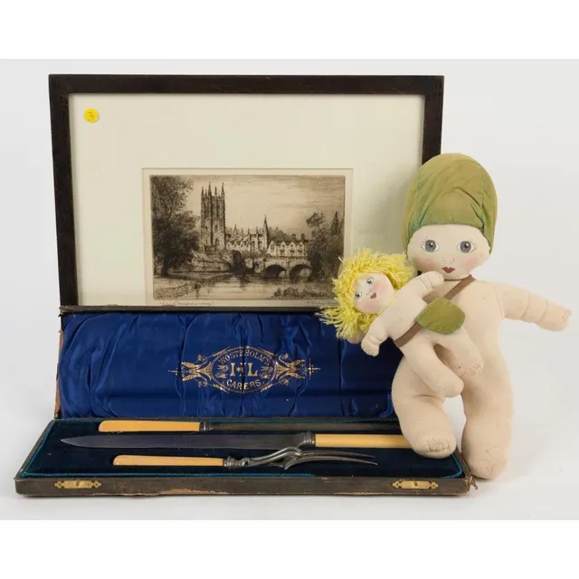
Oxford Etching, Carving Set, and Gumnut Dolls in Frame
A framed etching of Oxford, carving set and gumnut dolls, (3 items).

Antique Framed Coloured Engravings: Nouvelle-Hollande and Timor, 18th Century
Two antique framed coloured engravings: I.) Roger, Barthelemy (1767-1841, engraver); petit, Nicolas-Martin (1777-1804, artist) Nouvelle-Hollande. Cour-Rou-Bari-Gal. II.) Roger, Barthelemy (1767-1841, engraver); petit, Nicolas-Martin (1777-1804, artist)…
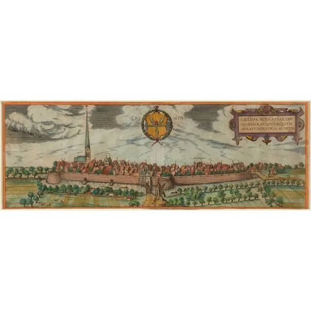
Historical Map of Holstein by Braun-Hogenberg, circa 1590
Crempa Holsatiae opp.(idum), Ioannis Ranzovii equitis aurati industria munitiss.(ima), hand coloured copper engraving from Braun-Hogenberg, circa 1590, 17 x 48 cm; framed 49 x 93 cm overall.
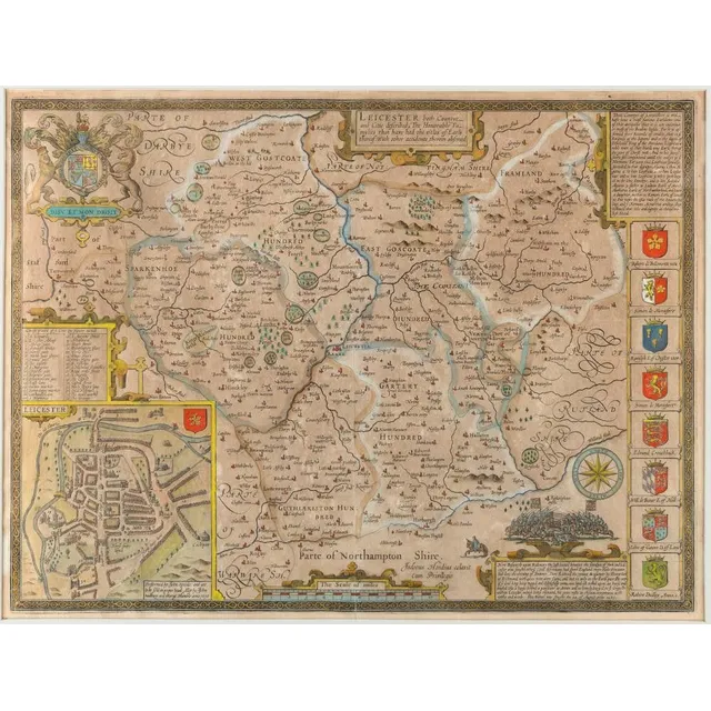
Leicester County and City: Honorable Families and Battle Scene
John Speed (1552 - 1629), 'Leicester, both Countye and Citie described, the Honorable Famylies that have had titles of Earls thereof. With other accidents therein observed.' copper plate engraving with later hand-colouring; circa 1616, with inset town…
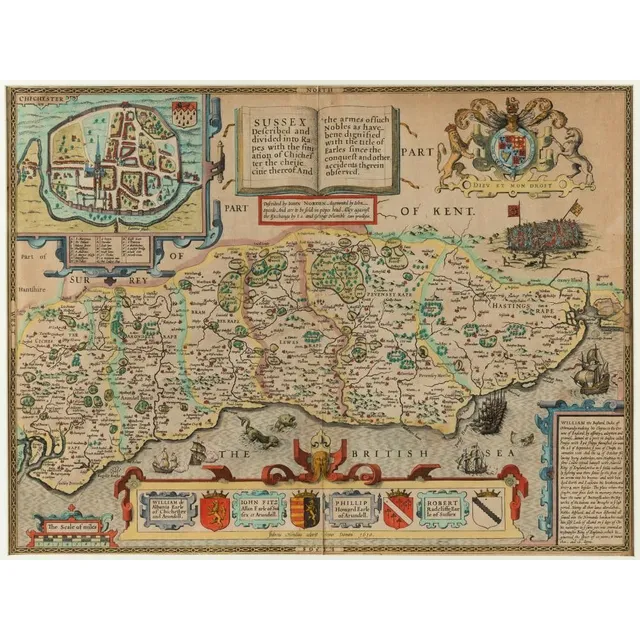
17th Century Sussex Map with Chichester Town Plan Engraving
John Norden & John Speed, 'Sussex Described and divided into Rapes...', circa 1627 copper plate engraving with later hand-colouring; with inset town plan of Chichester, 39 x 51 cm; framed 57 x 70 cm overall.
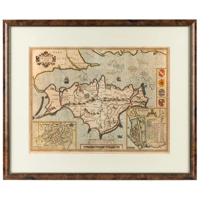
White Island: Newport and Southhampton Town Plans, 1627
John Speed & William white, 'White Island', circa 1627, copper plate engraving with later hand-colouring; published by Sudbury and Humbell, with inset town plans of Newport and Southhampton, 39 x 51 cm; framed 59 x 71 cm overall.
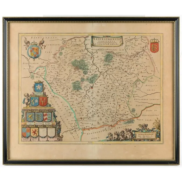
Leicestrensis Comitatus - Leicester Shire, 1662 Copper Plate Engraving
Joan Blaeu (1596 - 1673), 'Leicestrensis Comitatus - Leicester Shire', copper plate engraving, 1662, [Amsterdam, atlas Major...] with some hand colouring, 38 x 49 cm; framed 51 x 60 cm overall.
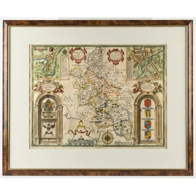
Buckinghamshire and Town Plans by John Speed, circa 1676
John Speed (1552 - 1629), 'Buckingham both Shyre and shire town describ.' circa 1676, copper plate engraving with later hand-colouring; with inset town plans of Buckingham and Redding (which are the earliest recorded) 38 x 50 cm; framed 58 x 70 cm overall.
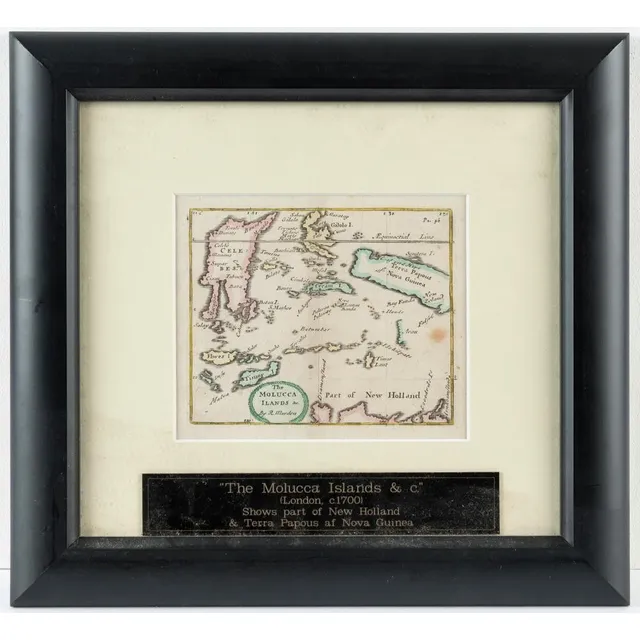
The Molocca Islands & New Holland Map, 1687
Robert Morden (d.1703), 'The Molocca Ilands &c', copper plate engraving, from Morden's 'Atlas Terestris', 1687, minor later hand-colouring, image 11 x 13 cm; framed 38 x 29.5 cm. Shows part of New Guinea and New Holland.
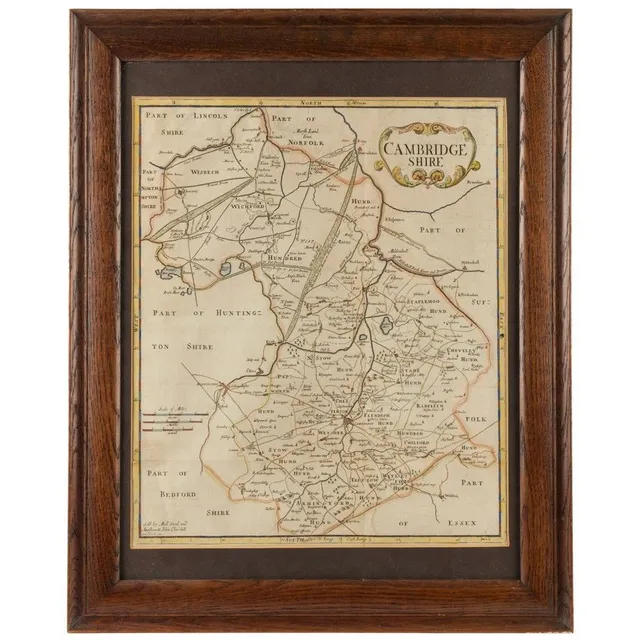
Cambridgeshire Map from Camden's Britannia, 1695 Hand-Colored Engraving
Robert Morden & Sutton Nicholls, 'Cambridgeshire', [from Camden's 'Britannia', 1695], hand coloured copper plate engraving, with the sellers' imprint of Abel Swal and Aunsham & John Churchill, 43 x 36 cm; framed 59.5 x 48 cm overall.
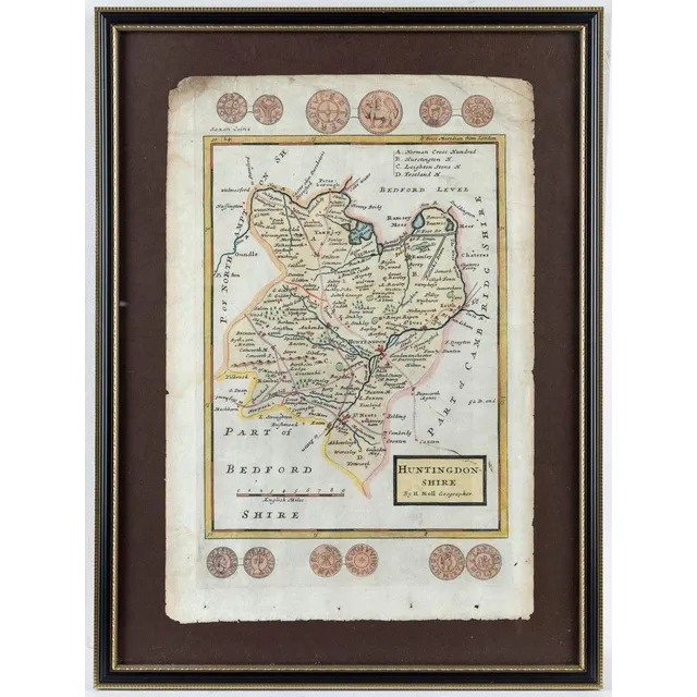
Herman Moll's Huntingdon-Shire Map, 1724
Herman Moll (1654 - 1732), Huntingdon-Shire, copper-plate engraving; hand coloured, [London, c.1724], from 'A new Description of England and Wales', 32 x 20 cm; framed 43 x 32 cm overall. Now a non-metropolitan district of Cambridgeshire.
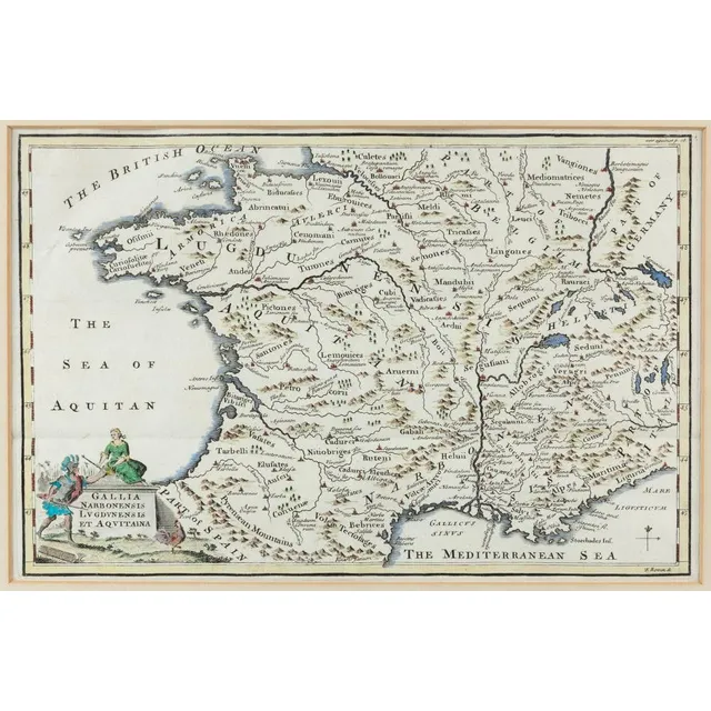
Gallia Narbonensis, Lugdunensis Et Aquitania, Copper Plate Engraving, 1747
Emanuel Bowen (1694 - 1767), Gallia Narbonensis Lugdunensis Et Aquitania, copper plate engraving with light hand-colouring, from ''The universal History...', 1747, 20 x 31 cm; framed 35 x 42.5 cm.
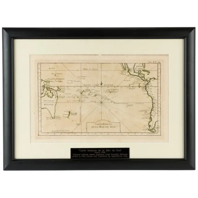
Early French map of the South Pacific, pre-Cook's voyages
Jacques Nicolas Bellin (1703 - 1772), 'Carte Reduite de La Mer du Sud,' Paris, circa 1760], copper engraving; some hand-colouring, 21 x 35 cm; framed 41 x 56 cm. Pre-dating Cook's voyages, New Guinea is shown joined to a speculative Australian East coast…
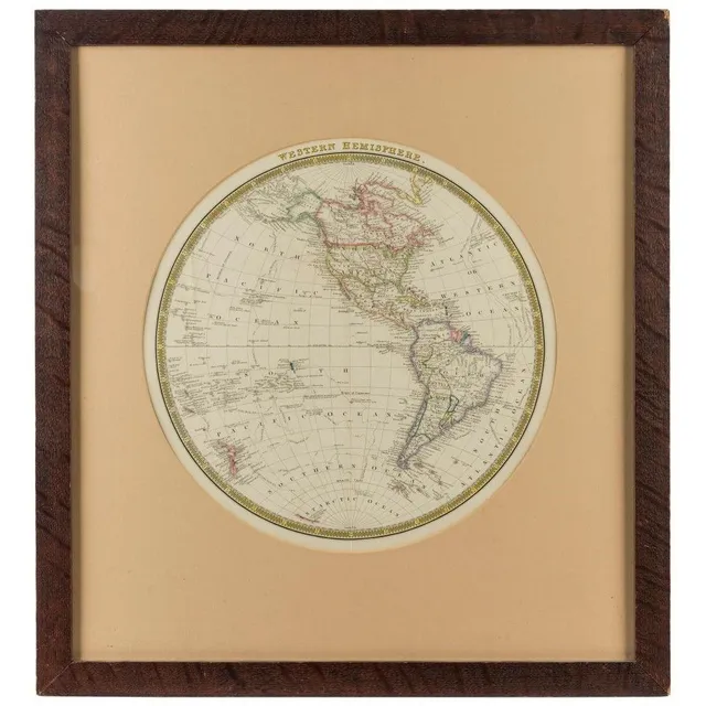
Exploration of the Western Hemisphere in the 19th Century
Henry Teesdale (1776 - 1855), Western Hemisphere, [London, circa 1845], steel engraving with some hand colouring, 36 cm diameter, 61 x 56 cm overall. While most entries make reference to Cook's voyages, there are two small references to Captain Ross'…
Vintage English tin litho money box with rabbits, 20th century
Chad valley vintage English tin lithograph money box with rabbits, 20th century (with original key), 15.5 cm high.
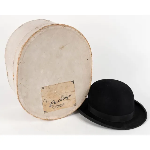
Antique Buckley's Bowler Hat in Original Card Hat Box
An antique bowler hat in original card hat box with lithograph label from 'Buckley's' of Melbourne